Arctic Circle Monuments & Markers Around The World

Base Image Source: Google Earth. [Click on image for Enlarged View]
- Viking Island (øya Vikingen)
- Coastal Route RV 17, Nordland
- Arctic Circle Centre, Saltfjellet
- Hwy 95 near Arjeplog, Norrbotten County
- Hwy E-45 near Jokkmokk
- Geografiska Polcirkeln/Piatis Railway Station
- Piatis-Smeds Road
- Hwy 97 to Mattisuden, Jokkmokk
- Road BD 811 near Nedre Kuouka
- Polcirkeln Village
- Härkmyran, Gällivare
- Hwy E-10, Near Överkalix
- Road BD-392, Lillselet, Överkalix
- Hwy 99, Juoksengi, Övertorneå
- Juoksenki
- Route 932, near Liinanki
- Santa Claus Village, Rovaniemi
- Route 945, Kemijärvi
- Route 9452, Soumu
- Hwy E-63 Near, Soumu
- Hwy E105/M18, Loukhsky, Karelia
- Unknown Road, Umba, Tersky, Murmansk Oblast
- Unknown Road, Usinsk, Komi Republic
- Salekhard
- Unknown place near Zapolyarnyy, Nadymsky District
- Unknown Road near Novy Urengoy, Yamal-Nenets
- Unknown Road near Novozapolyarny, Tazovsky District, Yamalo-Nenets
- Intersection of Anti-meridian (180° East/West)
- Lultin Road, Near Ozërnyy
- Dalton Highway
- Fort Yukon
- Dempster Highway, Yukon Territory
- Repulse Bay (Naujaat)
- Grimsey Airport, Grimsey Island
- "Arctic Henge", Raufarhöfn
- Although the Arctic Circle is officially defined at latitude 66° 33' 44" (66.5622°) but some monuments have been placed at 66° 33' 00" (66.55°).
- Sweden has maximum number of Monuments/Markers.
- Surprisingly there is no monument/Marker in Greenland (At least I couldn't find one).
- Most of the major Swedish highways crossing the Arctic Circle have a standard signboard which shows Arctic Circle cutting through the Map of Sweden with spot where the signboard is placed is marked on it by a red dot. The signboards also have "Arctic Circle" written in 5 different languages - Swedish, Finnish, English, French and German.
- Finland also has standard signboard design, similar to Sweden, but the "Arctic Circle" is written in six languages instead of 5; Finnish, Swedish, German, English, French and Russian.
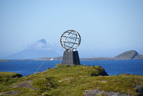
Image from Flickr is by Xesc Arbona
Image from Flickr is by Percita
View location in Google Maps
Arctic Circle Centre, Saltfjellet, Norway
Image from Panoramio is by Leif Rostgaard Nielsen
Image from Panoramio is by Jack globetrotter
Image from Panoramio is by valentin_orlov
Monument to those who died in the labour camps while constructing road/railway line during the Nazi occupation.
Image from Flickr is by jechstra
View location in Google Maps and Street View
Hwy 95 near Arjeplog, Norrbotten County, Sweden
Image from Panoramio is by Kronan
View location in Google Maps and Street View
Hwy E-45 near Jokkmokk, Sweden

Image from Flickr is by Laurent de Walick
Image from Flickr is by lemonad
View location in Google Maps and Street View
Geografiska Polcirkeln/Piatis Railway Station, Sweden
Image from Panormio is by birdah
Image from Panormio is by algolYz
View location in Google Maps
Piatis-Smeds Road, Sweden
Image from Panoramio is by apartmanslavonice
View location in Google Maps
Hwy 97 to Mattisuden, Jokkmokk, Sweden
Image from Panoramio is by Umeå
View location in Google Maps and Street View
Road BD 811 near Nedre Kuouka, Sweden
Image from Panoramio is by Vitaliy Sobutskyy
View location in Google Maps and Street View
Polcirkeln Village, Sweden
Image from Panoramio is by Jean-Paul Bardou
View location in Google Maps
Härkmyran, Gällivare, Sweden
Image from Panoramio is by lapplandfoto.se
View location in Google Maps
Hwy E-10, Near Överkalix, Sweden
image from Panoramio is by carmenlaura
View location in Google Maps and Street View
Road BD-392, Lillselet, Överkalix, Sweden
Image from Panoramio is by FragEgon
View location in Google Maps and Street View
Hwy 99, Juoksengi, Övertorneå, Sweden
Image from Panoramio is by Fraenzel
Image from Panoramio is by Станислав Дубенко
View location in Google Maps & Street View
Juoksenki, Finland
Image from Panoramio is by dr.eros

Image from Flickr is by Anna B
View location in Google Maps and Street View
Route 932, near Liinanki, Finland
Image from Panoramio is by ronalfredo
View location in Google Maps
Santa Claus Village, Rovaniemi, Finland

Image from Flickr is by derrickting
Christmas House (Souvineer Shop etc.)
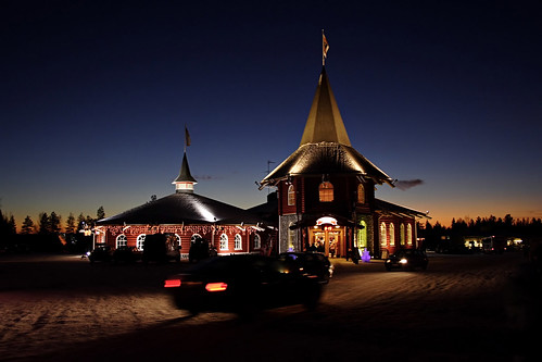
Image from Flickr is by Robert Parviainen
Arctic Circle line cuts through Santa's Office.
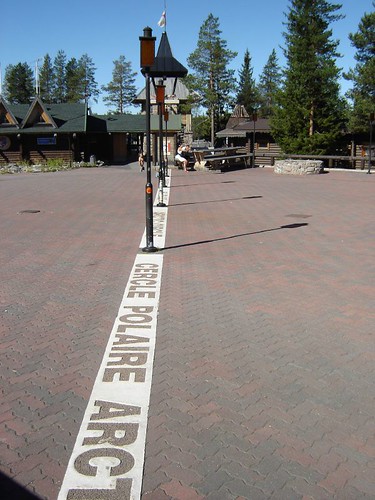
Image from Flickr is by Emiliano Marin
View location in Google Maps and Street View
Route 945, Kemijärvi, Finland
A small sign;

Image Source: Google Street View
Route 9452, Soumu, Finland
Image from Panoramio is by UL
Hwy E-63 Near, Soumu, Finland

Image Source: Google Street View
A snowman sculpture nearby
Image from Panoramio is by StanisławGoś
View location in Google Maps and Street View
Hwy E105/M18, Loukhsky, Karelia, Russia
Image from Panoramio is by crivoruchko
View location in Google Maps and Street View
Unknown Road, Umba, Tersky, Murmansk Oblast, Russia
Image from Panoramio is by SmEsHaRiK
View location in Google Maps
Unknown Road, Usinsk, Komi Republic, Russia
Image from Panoramio is by iSonnik
View location in Google Maps
Salekhard, Russia
Image from Panoramio is by dimamol
View location in Google Maps
Unknown place near Zapolyarnyy, Nadymsky District, Russia
Image from Panoramio is by vvg1958
View location in Google Maps
Unknown Road near Novy Urengoy, Yamal-Nenets, Russia
Image from Panoramio is by dimamol
View likely location in Google Maps
Unknown Road near Novozapolyarny, Tazovsky District, Yamalo-Nenets, Russia
Three monuments at same place;
Image from Panoramio is by realsasha
Image from Panoramio is by Savon Yuriy
Image from Panoramio is by Vghik
View location in Google Maps
Intersection of Anti-meridian (180° East/West), Russia
Image from Panoramio is by Александр Биушкин
View location in Google Maps
Lultin Road, Near Ozërnyy, Russia
Image from Panoramio is by Шабанов
View location in Google Maps
Dalton Highway, Alaska, USA
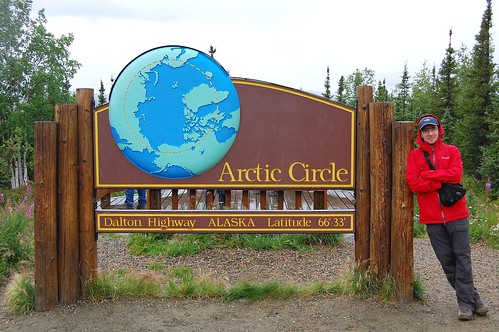
Image from Flickr is by Ilya Katsnelson
View location in Google Maps
Fort Yukon, Alaska, USA
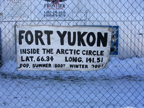
Image from Flickr is by Kirk Crawford
Image from Panoramio is by gkl
View location in Google Maps
Dempster Highway, Yukon Territory, Canada
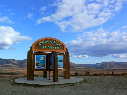
Image from Flickr is by Tania Liu
View location in Google Maps
Repulse Bay (Naujaat), Canada
Image from Panoramio is by lchernenko
View location in Google Maps
Grimsey Airport, Grimsey Island, Iceland

Image from Flickr is by William Wallace

Image from Flickr is by aleph78
View location in Google Maps
Arctic Henge, Raufarhöfn, Iceland

Image from Selka Kind's Blog "What we got up to in Iceland" is by Derek Kind.
(Permission to use image is gratefully acknowledged.)
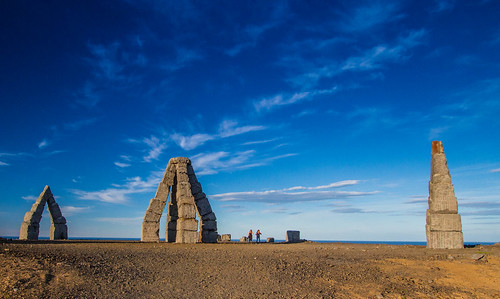
Image from Flickr is by Ólafur Gísli Agnarsson
Image from Panoramio is by Fritz Weinauer
Sun seen through the north gate - image taken from the south.

Image from Facebook - Arctic Henge's Photos is by Erlingur Thoroddsen
View location in Google Maps
____________________________
View All locations in Google Earth - Download kmz file.




0 comments:
Post a Comment