Tri-Bridges are 3-way bridges on which traffic crosses two
water streams or a body of water from three directions, and one can travel from
any direction to any other. Because of their shape, these bridges are generally
called tri-bridges, Y-bridges, or T-bridges.
One of the criteria I have used for inclusion in this
collection is that at least two spans should be over water.
It is also pertinent to note that many Y-Bridges are just
fork bridges where traffic from one direction bifurcates in two directions or
vice versa, and there is no three-way traffic. Such bridges have not been
included here.
In addition, there are some recently built 3-way interchange
bridges. It is debatable whether a 3-way or T-interchange can be classified as a
tri-bridge or not. In a classical sense, a T-interchange is not a tri-bridge, as
the interchange is built at 2–3 levels to allow unhampered 3-way traffic and
there is no physical trisection point. On the other hand, the conventional
tri-bridges have a distinct node or joint, and the traffic from three directions
physically merges or demerges over a trisection point on water. In all
likelihood, the future 3-way bridges in heavy traffic areas will be
T-interchange bridges, as conventional tri-bridges cannot cater to large flow of
traffic. As this collection is about conventional tri-bridges, I am not
including T-interchange bridges in this collection.
There are not many tri-bridges in the world. Till now, I have
been able to identify only forty-eight (48) tri-bridges, out of which there are
nineteen (19) regular vehicular bridges, twenty-seven (27) 3-way foot/cycle bridges,
and one (1) disused 3-way
footbridge.
Not included in this collection are 4-way bridges. These are
much rarer than the 3-way bridges and can be found in this post. However, one (1) 5-way footbridge, which is the only one
of its type, has been included in this collection.
The bridges included in this collection are listed continent
and country wise.
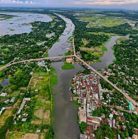
This Y-bridge over the Titas River at Charlohania, Brahmanbaria, is the
country's first ever tri-bridge. It is named after Bangladesh's prime minister
and is called "Sheikh Hasina Titas Bridge". The bridge inaugurated in September
2018 is 771 metres long and 8.10 metres wide and provides easy access to the
residents in the wide riverine area around Brahmanbaria.
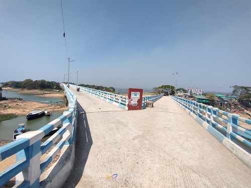
This 420-metre long and 4.5-metre wide Y-Bridge opened in
2022 connects by road the two islands of Jugolika Hill and Puratanbasti in the
Kaptai Lake to the main town of Rangamati and also provides a motorable
connection between the two islands.
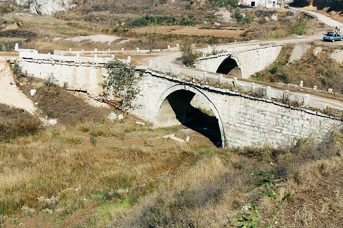
Located in Heicheng Village, Hebei Province, China, this road tri-bridge is locally known as Hama Bridge or
Sancha Zijin and was built circa 1691.
Google Maps
Credits: I am thankful to Bob (bridgeink.com) for informing me about this bridge as well as pointing out its exact location in China. Without guidance from him, I couldn't have found this bridge on Google Earth.
3-Way Mukkam Kadavu Bridge, Kerala, India
Also known as Vent Pipe Bridge, it is Located in Mukkam,
Kozhikode, at the confluence of the Iruvazhinji River with its smaller
tributary, the Manthra Kadavu River. From the picture shown below, it looks like
it is a replacement of an earlier 2-way bridge at the location. Google Earth
imagery of April 1, 2020, shows the other 2-way bridge. Subsequent imagery from
February 23, 2021, shows some piers of the other bridge. This
Google Street View posted on
September 2017 shows the other bridge in a dilapidated condition.
It is perhaps India's first tri-bridge. Its picture was
posted on
Facebook as early as November 27, 2014.

Image from
Wikimedia Commons is by Pkriyas.
Google Maps
T-Bridge, Cuttack, Orissa, India
This 3.4 km. long T-bridge over the Mahanadi River connects the townships of
Gopinathpur and Baideswar in Cuttack district. It also has a 240-metre long
tee-off to an island located in the middle of the river. The tee-off provides
permanent, all-weather access to the temple located on the island. Prior to the
building of this bridge, the state government used to build a pedestrian track
every year on the river bed for passage to the temple, and this track used to
get washed away during the rainy season.

Image from Google Maps is by
Sai Kalyan
Google Maps
Source of information:
newindianexpress.com
Credits: Krenek,
Member, Google Earth Community Forums, for bringing this bridge to my knowledge.
Aioi Bridge, Hiroshima, Japan
This "T"-shaped bridge is the historic and tragic bridge which was used as the
target point for the dropping of the first atom bomb on August 6, 1945. The bomb
missed slightly, exploding in the air over Shima Hospital, located 300 metres
away from the bridge. However, the bridge was badly damaged due to the blast.
The original bridge at the site, meant for streetcars, was completed on December
12, 1932, and had a width of 15 metres. Later in 1934, a 'Tee' connection was
added in its central section, which connected it to the island of
Jisenji-no-hana (present-day
Peace Memorial Park),
and it thus got this unique T-shape. Perhaps it was this unique and rare sight
which made it the centre of the target.
After the war, the bridge was repaired and put back in use, but the bomb had
taken its toll, and the bridge gradually deteriorated. A new bridge was
therefore constructed at the spot, having a total length of 123.4 metres, a
width of 40 metres, a streetcar track, six traffic lanes, and a pedestrian lane.
A few old pillars bearing the marks of the bombing are still preserved at the
foot of the present bridge as a mute witness to history. Some of the girders
deformed by the blast are also displayed in the
Hiroshima Peace Memorial Museum.
Model showing the town as it existed prior to bombing.
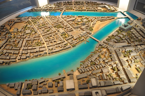
Image from
Flickr is by
austinmills
View of old pre-bombing bridge.

Image Source:
Wikimedia CommonsThe present bridge.
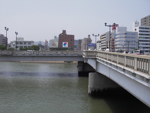
Image from
Flickr is by
Gaz Errant
Google Maps
Source of info:
pcf.city.hiroshima.jp
Chu Y Bridge, Ho Chi Minh City, Vietnam
Chu Y Bridge spans Tau Hu and Doi canals to link Nguyen Bieu
Street in District 5 and Hung Phu and Nguyen Thi Tan streets in District 8. The
original bridge at this location was built in 1937. However, to cater for the
rising needs of the traffic, it was renovated and enlarged as a part of the
East-West Highway Project. The new bridge was inaugurated on April 28, 2009.

Image Source:
Google Maps

Image from
Flickr is by manhhai
Google Maps
Source of info:
en.metvuong.com
Credits: I am thankful to Faysal Bin Darul, member, Google
Earth Community Forums, for bringing this bridge to my knowledge.
Mangakahia Twin Bridges, (Nukatawhiti, Northland), New Zealand
This Tri-Bridge located on the confluence of the Awarua River
and Mangakahia River, is a T-bridge but is locally known as Twin Bridges. The
Mangakahia Road, which passes over the two rivers, has a T-intersection in the
middle, with the third limb leading to a scenic reserve.

Image from Google Maps is by
Patrick
Google Street
View
Credits: I am thankful to Kevin Rikys whose comments on my blog (Travelogue
of An Armchair Traveller) brought this bridge to my knowledge.
T-Bridge, Hallein, Austria
A distinct T-bridge over the River Salzach at Hallein, Austria. The bridge,
officially Stadtbrücke (City Bridge), is about 110 metres long and connects the
old town of Hallein to the district of Burgfried. Midway, there is a tee-off to
Pernerinsel Island, which lies in the middle of the river.

Image Source:
Wikimedia Commons
Google Maps
Source of info:
Salzburg Wiki (In German) (English
Translation)
Jasenovac Tri-Bridge, Croatia
The original 1973 bridge at this location, across the Sava
and Una Rivers, was destroyed by Serb forces during the 1991 conflict. A new
Y-shaped bridge was built in 2005. One arm of the bridge starts from Jasenovac,
spanning the Sava river with a Y-junction in the Uštica. The second arm takes
the traffic to Uštica and the third arm, which spans the Una river, crosses the
international border connecting Croatia with Bosnia and Herzegovina.

Image Source:
Google Maps

Image Source: Google Maps
Source of info:
Wikipedia.
Pierre Corneille Tri-Bridge, Rouen, France
Pierre Corneille Bridge connects the right bank of the River
Seine to its left bank through Lacroix Island, Rouen. There is a small T-off
bridge to the island, making it a Tri-Bridge. The bridge is named after the
famous French writer Pierre Corneille.
A bridge built in 1829 stood here until it was destroyed on
June 9, 1940, by French engineers on the arrival of the German army in the city.
The present bridge was built in 1952.

Image Source: Google Maps

Image Source: Google Street View
More info:
French Wikipedia
(English Translation)
Margaret Bridge (Margit Hid), Budapest, Hungary
Margaret Bridge (Margit híd) connects Buda and Pest across the river Danube. It
was built between 1872 and 1976 and is the second-oldest bridge in Budapest and
one of the most widely used. The main bridge has an angle of 165 degrees, is
637.5 metres long, and is 25 metres wide. Near the midpoint, there is a small
third arm leading to Margaret Island. This extension was added to the design at
the last stages of design and was built almost 20 years after the completion of
the main bridge due to lack of funds.

Image from
Wikimedia Commons is by Civertan

Image Source
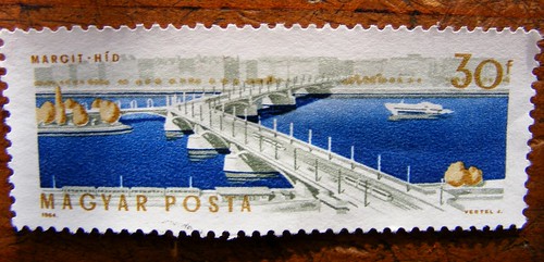
Image from
Flickr is by
DurhamDundee
Source of info:
Wikipedia
Google Maps
Credits: I am thankful to
Syzygy, Moderator, Google Earth Community Forums, for bringing this bridge
to my knowledge.
Bridge with Three Entrances (Ponte das Três Entradas),
Portugal
Ponte das Três Entradas (Bridge with Three Entrances)
is a Y-bridge on the confluence of the rivers Alvoco and Alvo in Porugal.
Located near Oliveira do Hospital, Santa Ovaia, Coimbra, it was built in 1899,
and its construction opened up the whole area, connecting the three neighbouring
towns of São Sebastião da Feira, Santa Ovaia, and Aldeia das Dez.
Because of its unique shape and location, the settlements in
the vicinity are also known as 'Ponte das Três Entradas'. The area has also now
become a camping site and draws tourists for outdoor activities like fishing and
canoeing etc.

Image source:
Google Maps

Image Source
Source of info:
relvadotrigo.com
Google Maps
Credits: I am thankful to mjoaoh, for bringing this bridge to
my knowledge.
Tripartite (Three-Arched) Bridge, Saint Petersburg, Russia
Commonly called "Tripartite Bridge" or "Three-Arched Bridge",
it is actually a pair of two bridges perpendicular to each other and joined in
the middle of one of the bridges. One of the bridges is a 15-metre-long Theatre
Bridge across the Griboyedov Canal, and the second bridge, which connects to the
centre of the Theatre Bridge, is the 18-metre-long Malo-Konyushennyi Bridge
across the Moika River. Both bridges rest on a single pier, which forms the
junction of the two bridges.

Image Source:
Google Maps
(Terrain View)

Google Maps
(Satellite View)
Source of information:
Wikipedia
Strömsborg Bridge, Stockholm, Sweden
Strömsborg Bridge (Swedish: Strömsborgsbron)
in the old city of central Stockholm, Sweden connects the Strömsborg Islet in
the River Norrström to the main Vasa Bridge thereby creating a classical 3-way
T-junction.
The Islet was originally accessible from west
side via the Central Bridge (Centralbron) through a causeway built in
1873. In 1954, the Central Bridge was replaced by a new bridge and the Islet was
connected from east side to Vasa Bridge by a tee-off in it. The present bridge
was built in 1992-1993 and opened on 9 July 1993.

Image Source: Google Maps
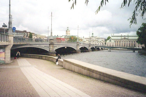
Image from Flickr
is by Bob
Google Street View
Source of info:
Swedish Wikipedia (English
Translation)
Credits: I am thankful to Bob (bridgeink.com)
for informing me about this bridge.
Louisa/Fort Gay Tri-Bridge, Kentucky and West Virginia,
USA
The Louisa Louisa/Fort Gay Tri-Bridge at the confluence of
the Levisa and Tug Rivers is a T-shaped bridge. Opened in 1906, it is reportedly
the only bridge in the U.S.A. which not only spans two rivers but also connects
two states (Kentucky and West Virginia), two counties (Lawrence County,
Kentucky, and Wayne County, West Virginia), and two cities (Louisa, Kentucky,
and Fort Gay, West Virginia).
Its third arm in the centre connects to a land mass in
Louisa, KY, which lies just upstream of the confluence point of the two rivers.
This land mass is known as "The Point Section". Locals enjoy giving directions
to strangers wanting to go to the Point section. In the words of my blog's
reader vldecker;
' ...... when someone from out of town asked directions to "The Point Section"
it was always fun to tell them to "go to the middle of the bridge and turn
right"...... '

Image Source:
facebook.com/FKellyDrone (Permission to use the image is awaited).
Source of info: Comments
by reader vldecker and Lawrence County Clerk's
Web page
Google Maps
Credits: I am thankful to reader vldecker, whose
comments on my post brought this bridge to
myknowledge.
T-Bridge, Lowell, Ohio, USA
A classical T-bridge over the Muskingum River at Lowell, Ohio. This is the
second tri-bridge over the Muskingum River. The other bridge is a Y-Bridge at
Zanesville, Ohio.

Image Source: Google Maps
Google Street View
Y-Bridge, Zanesville, Ohio, USA
This road bridge is an historical bridge in Zanesville, Ohio,
and is popularly known as "Y-Bridge." Located in Zanesville, it spans the
confluence of the Licking and Muskingum Rivers and is officially called the
Muskingum River Y Bridge. The bridge is a big land mark and was even used as an
aviation marker for many years.
Amelia Earhart, the
famous American aviation pioneer, was quoted as saying “Zanesville is the
easiest recognized city from the air because of the Y- Bridge".
The present bridge which is 5th at the spot, was opened in
1984. The first Bridge at this location was a wooden bridge and was built around
1814.

Image from Google Maps is by
Kyle H

Image from Google Maps is by
Malenky
Google Street ViewSource
of Info:
Wikipedia
Chincoteague Causeway, Chincoteague, Virginia, USA
The John B. Whealton Memorial Causeway, (locally known as the
Chincoteague Causeway) connects the mainland of the Eastern Shore of Virginia to
Chincoteague Island. A connecting spur from Marsh Island joins the main bridge
at a T-intersection over the water, making it a classical three-way Tri-Bridge.

Image Source: Google Street View
(Photosphere) by
Riley
Samora
Google Maps
More info:
Wikipedia
Y-Bridge, Pingshan, Shenzhen, China
A covered Y-bridge spanning the Pingshan River, connecting
the Pingshan High School on the north bank to the south bank, which has a number
of residential, commercial, and office buildings. Prior to the construction of
this 70-metre long bridge, there was no other bridge available for pedestrians
within a kilometre's walking distance of the school, resulting in traffic
bottlenecks during school hours. The bridge, which was built in 2019, now allows
instructors, students, and residents to easily commute between the two banks of
the river.

Image Source: Google Maps
Source of information with some good pictures:
archdaily.com
Kang Ding Tri-Bridge Ganzi, Sichuan, China
A small Tri-Bridge, in one of the most remote areas of the
world, spanning the confluence of two small mountain streams in the town of Kang
Ding, Ganzi (aka Garzê), Sichuan, China. Kang Ding is the traditional border
town between China and Tibet.

Image Source: Google Maps
Kikko Tri-Bridge, Mie, Japan
Kikko Tri-Bridge is a three-legged footbridge in Aoyama-Kohgen
Golf Club, Mie, Japan. It was built in 1991 and gives easy access from the
clubhouse to the golf courses around a small pond. The legs vary in length from
about 40.5 metres to 44 metres.

Image Source: Google Maps

Image from
Google Maps is by
sato koji
Google Street View
Source of info:
Kappa Club (in Japanese) (English
Translation)
X-Bridge, Tokyo, Japan
A beautiful-looking elongated X-shaped bridge over the Sumida
River. The area is famous for its cherry blossom trees, which are situated on
both sides of the Sumida River, and many people cross this bridge during the
cherry blossom viewing season to see the blossoms on both sides of the river.
Because of this, the bridge is called Sakurabashi (Cherry Blossom Bridge). The
169.45-metre long and 6-metre wide (width in the centre is 20 metres) bridge was
opened in 1985.

Image from Flickr
is by Bob. This picture
was taken from the nearby Tokyo Skytree TV Tower, the tallest tower in the
world.
Google
Maps
Source of information:
Japanese Wikipedia (English
Translation)
Credits: I am thankful to Bob (www.bridgeink.com)
for informing me about this bridge.
Y-Shaped Suspension Bridge, Geochang-Udusan, Gajo-myeon, South Korea
Built in 2020, it is a Y-shaped hanging pedestrian bridge dangling 600 metres
above the ground without any support in the middle. It connects the mountainous
area around the ravine below.

Image from Google Maps is by
선녀의나무꾼
(선녀의나무꾼)
Google Maps
Source of information:
hapskorea.com
Butterfly Bridge, Copenhagen, Denmark
A unique and the only 3-way bridge in the world in which two
sections open up like a drawbridge to allow passage of sailboats in these
canals. Built in January 2015, the foot and cycle bridge, spanning
Christianshavns and Trangraven Canals in Copenhagen, has two movable decks which
operate independently of each other and are raised to allow canal traffic to
pass. When the two sections are drawn up at the same time, they look like the
wings of a large butterfly, hence the name.
Designed by Dietmar Feichtinger Architectes, the three
sections of the bridge meet over water to form a classical "Y" bridge. The
bridge has a width of 7.9 metres, and the two movable sections, which are
operated by hydraulic cylinders, are 23.3 metres long and, when raised, offer a
clear 15-metre-wide opening. The fixed span of the 3-way bridge is 7.80 metres,
plus a cantilever connection of 2.60 metres to the canal bank.

Image Source:
Google Maps


Google
Maps
Source of info and detailed info: Official Web page of
Dietmar
Feichtinger Architectes.
Some great images in
Arch Daily
Credits: I am thankful to:
- Dietmar Feichtinger
Architectes / Barbara Feichtinger-Felber for allowing the use of images
from their web page.
- Krenek,
Member, Google Earth Community Forums, for bringing this bridge to my
knowledge.
Double Y-Bridges, Under The Three Bridges, Viby, Denmark
It is an unusual shaped bridge with two Y
shaped spans on the each bank of the Arhus River connected by a longer span over
the river thus forming a double Y. The middle span lies under 3 railway bridges
spanning the river. The railway bridges are known as De Tre Broer (The
Three Bridges) and due to it location this pedestrian and cycle bridge is known
as the "Bridge under the Three Bridges".

Image Source: Google Maps
Source of information:
aarhusarkivet.dk
Eco-Viikki 3-way Bridge, Helsinki, Finland
A nondescript 3-way footbridge in Eco Viikki Housing near
Helsinki, Finland.

Image Source
Google Maps
Credits: I am thankful to:
- Noisette,
Administrator and Master Guide, Google Earth Community Forums, for bringing
this bridge to my knowledge.
- Jonathan Dowse for allowing me
to use the above image from his blog
jbdowse.com.
Bridge With 3 Branches, Pont-de-Veyle, Ain, France
Le pont à 3 branches (Bridge with 3 branches), Pont de
Veyle, Ain, France, is a small footbridge spanning the River Veyle and its
secondary stream, Little Vale. It is one of the seven other bridges in the park
of the Chateau of Pont-de-Veyle, all designed differently.
The bridge is not visible in the Google satellite imagery;
however, its shape can be made out in the French mapping service Géoportail.

Image source: geoportail.gouv.fr

Image from Google Maps is by
Pat Rick
Google Maps
Tri-Bridge, Amstelveen, Holland
A small tri-bridge under a disused railway line. The bridge
is meant for pedestrians and cyclists and the leg of the bridge which passes
under the rail track leads to "De Braak", a botanical garden in Amstelveen.


Image Source: Google Maps
Credits: I am thankful to
Martin
Klumper for informing me about this bridge as well as e-mailing me its
picture, information, and exact location.
Stania State 3-way Footbridge, Oentsjerk, Holland
A nice little 3-way bridge hidden amongst the trees in the
Dutch resort "Stania State" in Oenstjerk, not far from Leewarden.

Image Source (Permission of
Martin
Klumper to use the image is thankfully acknowledged).
Likely location in
Google Maps.
Not visible in the satellite imagery and the location is based on the above
image which can be seen in
web.archive.org. The bridge however can be seen in
Google Street View.
Vijversburg Estate Tri-Bridge, Tietjerk, Holland
A rustic wooden pedestrian tri-bridge at
Vijversburg Estate, Tietjerk, Holland. The bridge is located in a public
park, Bos van Ypey (Forest of Ypey), which is part of the estate. No
details about the bridge are available; however, as per Martin, who informed me
about this bridge, the bridge has recently been renovated.

Image from
Google Maps is by
Martin
Klumper

Image Source:
Google Maps
Credits: I am thankful to
Martin
Klumper for informing me about this bridge and also allowing me to use the
above image, which was originally posted in the now-defunct
Panoramio.
Noabers Bridge, Veelerveen, Holland
A classical 3-way bridge at the convergence of the Mussel-Aa
channel and the Ruiten-Aa channel. These channels run through the village of
Veelerveen, and the bridge connects the residents with each other, hence its
name, Noabers (neighbour's) Bridge. Built in 1989, the bridge is meant for
pedestrians and cyclists only. Due to its 3-pointed star shape resembling the
logo of Mercedes-Benz, it is also called "Mercedes Bridge".

Image Source: Google Maps

Image Source:
Wikimedia
Commons
Source of info:
Dutch Wikipedia (English
Translation)
Three Way Bridge at Fogelsangh State, Veenklooster,
Holland
A cute little tri-bridge in the English style park of
Fogelsangh State in Frisian village of Veenklooster, Holland.
The bridge was constructed in 1850 as part of landscaping of
the park which was designed by Dutch landscape architect Lucas Pieters Redbeard.

Image from Google Maps is by
Martin
Klumper
Google Maps
Credits: I am thankful to
Martin
Klumper for informing me about this bridge and also allowing me to use the
above image, which was originally posted in the now-defunct
Panoramio.
Ypsilon Pedestrian Bridge, Drammen, Norway
A cable-stayed 3-way pedestrian and cycle bridge over the River Drammen in
Drammen, Norway. The bridge was named after the Greek alphabet "Ypsilon" (or
Upsilon), which looks like a "Y". Designed by the architect firm Arne Eggen, the
bridge was commissioned in 2008.

Image from
Wikimedia Commons is by Unioneiendom

Image from
Wikimedia Commons is by
Petter Ulleland
Google Maps /Google
Street View
More info:
architecturenorway.no
Credits: I am thankful to Sladys whose comments in
Google Earth Blog brought this bridge to my knowledge.
Madrid Río Y Bridge, Madrid, Spain
This small Y-Bridge is part of the Madrid Río project for the
beautification of the Manzanares River. The Madrid Río project was conceived
when a portion of the Madrid ring road (M-30), which was running parallel to the
river, was shifted underground, thereby creating about 10 kilometres long empty
space along the river. This space has been utilised for the beautification of
the river bank by creating parks, pathways, and a range of sports, leisure, and
cultural facilities.

Image Source:
Google Maps

Image from Google Maps is by
Francesco
Bonadiman
Google Street View
More info: Madrid Rio
Project
Bergues Bridge, Genève, Switzerland
Bergues Bridge (Pont des Bergues) on the Rhone River
in Geneva, Switzerland, is a pedestrian bridge. Built in 1881, it has a tee-off
in the middle leading to Rousseau Island in the Rhone River. On May 22, 1990,
Swiss Post issued a set of four stamps on the occasion of the "1990 Geneva
Exhibition". One of the stamp in the set was the Bergues Bridge.

Image Source : Google Maps 45 Degree View

Image Source:
bridges.blog.sohu.comGoogle Maps
More info: French
Wikipedia (English
Translation)
Lune Millennium Bridge , Lancaster, England
The Lune Millennium Bridge which spans the River Lune, is a
cable-stayed footbridge in Lancaster, England. Like other millennium bridges in
UK, it was also built to commemorate year 2000.

Image from
Google Maps is by
Neil Fisher

Image from Google Maps is by
Jomo
Google Maps
More info:
Wikipedia
Credits: I am thankful to Matt Fletcher whose comments in
Google Earth Blog brought this bridge to my knowledge.
Three Legged Bridge, Milton Keynes, England
A classical 3-way footbridge bridge over the Grand Union
Canal at the Campbell Wharf Marina, Milton Keynes. It provides easy access
between the towpath of the canal, the Campbell Wharf Marina, and the nearby
residential development.

Image from Google Maps is
Colin
Durrans (minisumo)

Image Source: Google Maps
Google Street View
Thetford Tri-Bridge, Norfolk, England
A 3-way footbridge in Thetford, Norfolk, where the river
Little Ouse joins the River Thet. It links the River Side Walk (town centre)
with the bus station and Butten Island.

Image Source:
Google Maps

Image Source:
geograph.org.uk
Credits: I am thankful to Dick T, whose comments on my post
in the (now defunct) Google Earth Community brought this bridge to my knowledge.
Colin Glen Forest Park Tri-Bridge, Northern Ireland
A simple Y-shaped footbridge in the Colin Glen Forest Park
Tri-Bridge, Near Belfast, Northern Ireland. No image or details of this bridge
could be found except that it is part of the Ballycullo and Hannahstown Walks in
the Colin Glen Forest Park.
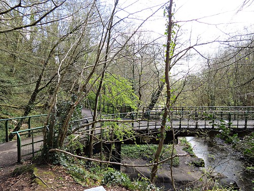
Image from
Flickr is by
Beechgarave (Permission to use the image is thankfully acknowledged.)

Image Source: Google Maps (Visible in
the January 4, 2007 imagery of Google Earth.)
Credits: I am thankful to
George S., Esq., Member, Google Earth Community Forums, for bringing this
bridge to my knowledge.
Tri-Bridge Stockingfield, Glasgow, Scotland
Stockingfield tri-bridge is a new pedestrian and cycle bridge
located in Glasgow, Scotland, which opened in December 2022. The bridge spans
the Forth and Clyde Canal at Stockingfield Junction and connects the communities
of Gilshochill, Maryhill, and Ruchill. The 3.5 metre wide bridge consists of two
single span decks suspended on a network of cables connected to a single
inclined pylon situated on the east bank of the canal.

Image from Google Maps is by
James Law

Image from Google Maps is by
Lawrence
Wong
The bridge is not yet visible in the satellite imagery of Google Maps but can
be seen in Google Street View.
Source of info:
balfourbeatty.com
Raehills Three-Way Footbridge, St Ann's, Lockerbie,
Scotland
A 3-way pedestrian bridge on the private property of the Hope
Johnson family of Raehills. Built in the late 19th century, it formed part of a
circular garden walk known as Wallace Loup along both sides of the Kinnel Water.
The bridge is made of 42 to 46-foot-long timber beams resting over a central
pier of masonry in the river. A small decorative pagoda tops the central pier.

Image from Flickr is by Douglas Campbell (Permission to use the image is thankfully acknowledged.)
Source of info:
Scotland Places
Google Maps (Note:
The bridge is not visible in the Google Earth imagery and the location has been
placemarked based on the map given in
Scotland Places.
Credits: I am thankful to
George S., Esq., Member, Google Earth Community Forums, for bringing this
bridge to my knowledge.
The Tridge, Brighton, Michigan, USA
While Tri-Bridges are a rarity elsewhere, they appear to be very popular in
Michigan. This is the third one in the state, the other two being in Midland and
Ypsilanti, respectively. All three are known as Tridge (short form for
Tri-Bridge). I wonder if this naming is intentional or co-incidental.
This 3-way bridge is a very popular location in town as it connects the
business centre to the heavily wooded trail along the Millpond. An annual "Tridge-or-Treat
Halloween Spooktacular" is held every year near the Tri-Bridge.

Image Source: Google Maps

Image from Google Maps is by
JimTobita
Google Maps
The Tridge, Midland, Michigan, USA
A 3-way footbridge located on the confluence of the Chippewa
River and Tittabawassee River is known as "The Tridge", a local slang for
tri-bridge. Constructed in 1981, it has since become an icon of the city and is
the most famous landmark in the downtown area.
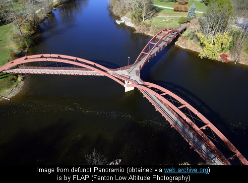
Image Source
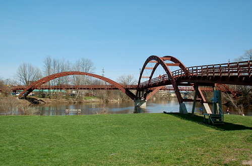
Image from
Flickr is by
Phil
Squattrito
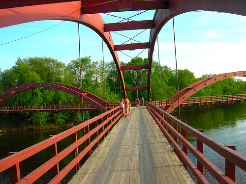
Image from
Flickr is by
Bluejacket
Google
Maps
Source of info:
Wikipedia
The Tridge, Ypsilanti, Michigan, USA
A 3-way wooden footbridge which connects Riverside Park, Frog
Island Park, and Depot Town is also locally known as The Tridge. It is situated
under the Cross Street bridge over the Huron River.
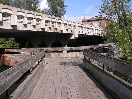
Image from
Flickr is by
shop_ypsi

Image Source: Google Maps
Source of info:
Arborwiki
Tri-bridge, Evergreen Girl Scout Camp, Longview,
Washington, USA
A foot bridge over the Mill Creek.
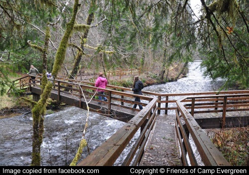
Image Source:
facebook.com/FriendsofCampEvergreen (Permission to use the image is
awaited).
Google Maps
Credits:
Krenek, Member,
Google Earth Community Forums, for confirming that it is a tri-bridge and also
finding its picture on the Internet for use here.
Unique 5-Way Bridge, Comacchio, Italy
This is a very unusual bridge, probably the only one of its kind: a 5-way bridge
at the intersection of five canals. Located in the small village of Comacchio,
Italy, it is known as Treponti (3 bridges) and was built in 1634. It has
three accesses points on the front and two on the back.
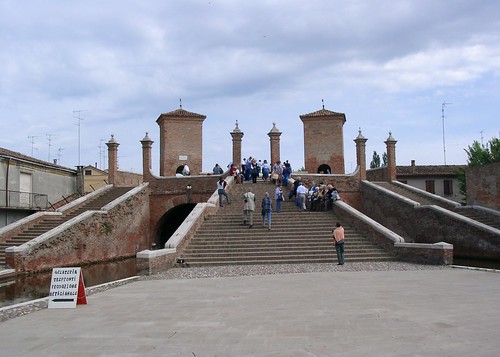
Image from
Flickr is
Noel
Cosgrave

Image from
Flickr is by
Bob
(Permission to use the image is thankfully acknowledged.)

Image source:
Google Maps
Source of info:
Flickr
Trinity Bridge, Crowland, Lincolnshire, England
Trinity Bridge is a disused three-way bridge in Crowland, Lincolnshire. The
bridge has three stairways that converge at the top. It is perhaps the oldest
3-way bridge in the world, as well as one of the oldest stone bridges in
England. The current bridge, which dates to the 14th century (built between 1360
and 1390), is now grade I listed.
Originally, it spanned the river Welland and its streams Nene and Catwater,
which flowed through the town. The streams were later rerouted, and the bridge
now sits high and dry in the centre of the town.

Source:
gutenberg.org
The text accompanying the above image reads:
"The curious bridge at Crowland near Peterborough (fig. 5) which now spans roadways, the streams which formerly flowed under it having been diverted, is one of the earliest known stone bridges in England. It is referred to in a charter of the year 943. It was probably built by abbots ......."
"A Topographical Dictionary of England (1848)" also mentions that:
"The Town, which is accessible only by artificial roads, consists chiefly of four streets, separated by watercourses, and communicating with each other by means of an ancient triangular stone bridge of singular construction, erected in the reign of Edward II. The bridge has one principal and finely groined arch, from which diverge three pointed arches over the streams Welland, Nene, and Catwater
....... " (Source:
geograph.org.uk)

Image from
Google Maps is by
Marcin
Kaczmarek
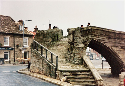
Image from
Flickr is by
Bob
Google Maps /
Google Street View
Credits: I am thankful to Bob (www.bridgeink.com) for informing me about this bridge.