The Arctic Circle lies at latitude 66° 33' 44" (or 66.5622°) north of the
Equator. It marks the southern extremity of the 24-hour sunlit day (Midnight Sun
aka Polar Day) and the 24-hour sunless night (Polar Night).
The Arctic Circle passes though Norway, Sweden, Finland, Russia, Alaska
(USA), Canada, Greenland (Denmark), and Grimsey Island (Iceland). Most of
regions through which the circle passes are uninhabitable due to harsh cold
climate, however several towns do exist within the circle.
In few towns around the World, Arctic Circle Monuments/Markers have been erected
generally on the travelling routes crossing the line and few places have
amusement park or shopping place/cafeteria etc. to attract tourists. I have tried to locate such monuments/markers and
placed marked these in Google Earth.

Base Image Source: Google Earth. [Click on image for Enlarged View]
Presently following locations have been identified and place
marked. These are listed below in sequential order,
travelling east from the Prime Meridian.
Norway
- Viking Island (øya Vikingen)
- Coastal Route RV 17, Nordland
- Arctic Circle Centre, Saltfjellet
Sweden
- Hwy 95 near Arjeplog, Norrbotten County
- Hwy E-45 near Jokkmokk
- Geografiska Polcirkeln/Piatis Railway Station
- Piatis-Smeds Road
- Hwy 97 to Mattisuden, Jokkmokk
- Road BD 811 near Nedre Kuouka
- Polcirkeln Village
- Härkmyran, Gällivare
- Hwy E-10, Near Överkalix
- Road BD-392, Lillselet, Överkalix
- Hwy 99, Juoksengi, Övertorneå
Finland
- Juoksenki
- Route 932, near Liinanki
- Santa Claus Village, Rovaniemi
- Route 945, Kemijärvi
- Route 9452, Soumu
- Hwy E-63 Near, Soumu
Russia
- Hwy E105/M18, Loukhsky, Karelia
- Unknown Road, Umba, Tersky, Murmansk Oblast
- Unknown Road, Usinsk, Komi Republic
- Salekhard
- Unknown place near Zapolyarnyy, Nadymsky District
- Unknown Road near Novy Urengoy, Yamal-Nenets
- Unknown Road near Novozapolyarny, Tazovsky District, Yamalo-Nenets
- Intersection of Anti-meridian (180° East/West)
- Lultin Road, Near Ozërnyy
Alaska (USA)
- Dalton Highway
- Fort Yukon
Canada
- Dempster Highway, Yukon Territory
- Repulse Bay (Naujaat)
Iceland
- Grimsey Airport, Grimsey Island
- "Arctic Henge", Raufarhöfn
Note regarding location:
Most of these locations were found by moving along
the Arctic Circle in Google Earth and Checking for Panoramio
images and Google Street Views, especially at the roads crossing the
Arctic Circle. The GE imagery at most of the locations is poor and it was not possible to accurately find
the correct position of some of the monuments/markers. I have arbitrarily placemarked these places and will correct the location as and when I get more information about these monuments/markers.
I Also request my readers to let me know if I have missed out any monument/marker or
if there is any error or discrepancy in the description or location in Google
Earth.
Some Observations;
- Although the Arctic Circle is officially defined at latitude 66° 33' 44" (66.5622°) but some monuments have been placed at 66° 33' 00" (66.55°).
- Sweden has maximum number of Monuments/Markers.
- Surprisingly there is no monument/Marker in Greenland (At least I couldn't find one).
- Most of the major Swedish highways crossing the Arctic Circle have a standard signboard
which shows Arctic Circle cutting through the Map of Sweden with spot where
the signboard is placed is marked on it by a red dot. The signboards also
have "Arctic Circle" written in 5 different languages - Swedish,
Finnish, English, French and German.
- Finland also has standard signboard design, similar to
Sweden, but the "Arctic Circle" is written in six languages instead of 5; Finnish, Swedish, German, English, French and Russian.
Brief description and/or images of each location is given below;
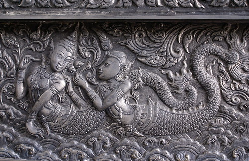
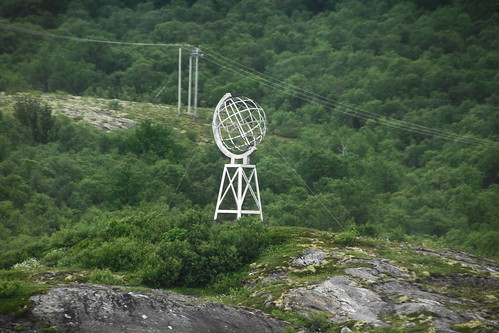
Viking Island (øya Vikingen), Norway
This monument on Viking Island, a small island in Rødøy municipality, Norway, is a favourite photographic object for travellers crossing the circle aboard a cruise ship.
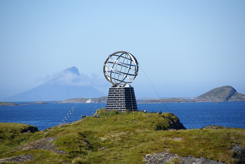
Image from
Flickr is by
Xesc Arbona
As per
Hurtigruten In Pictures the Globe was blown away by hurricane
"Arve" which passed over the island in January 2006 and has been built again on a solid base now instead of steel frame base. Following image shows the earlier monument after the hurricane.
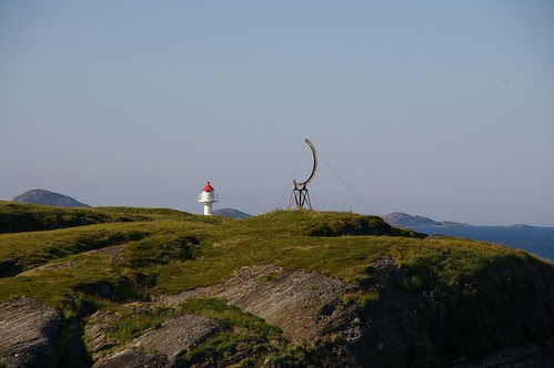
Image from
Flickr
is by
Percita
View location in
Google Maps
Coastal Route RV 17, Nordland, Norway
View location in
Google Maps
Arctic Circle Centre, Saltfjellet, Norway
Saltfjellet region in Norway has marked the Arctic Circle in a big way by building a "Arctic Circle Centre"
(Polarsirkelsenteret) at the intersection of E6 highway with the Arctic Circle. The Centre, which was opened on July 13, 1990, contains a cafeteria, a cinema, exhibition hall/information centre and souvenir shop.
There are four monuments at the Arctic Circle Centre. Three of these relate to the Arctic Circle and the fourth is a monument to those who died in the labour camps while constructing road/railway line during the Nazi occupation.

Image from
Panoramio is by
Leif Rostgaard Nielsen

Image from
Panoramio is by
Jack globetrotter

Image from
Panoramio is by
valentin_orlov
Monument to those who died in the labour camps while constructing road/railway line during the Nazi occupation.

Image from
Flickr
is by
jechstra
View location in
Google Maps and Street View
Hwy 95 near Arjeplog, Norrbotten County, Sweden

Image from
Panoramio is by
Kronan
View location in
Google Maps and Street View
Hwy E-45 near Jokkmokk, Sweden

Image from
Flickr
is by
Laurent de Walick

Image from
Flickr
is by
lemonad
View location in
Google Maps and Street View
Geografiska Polcirkeln/Piatis Railway Station, Sweden
A train stop near the Arctic Circle about 10 miles south of Jokkmokk on the Jokkmokk - Kåbdalis rail line.
Google Maps names this as "Geografiska Polcirkeln" while
Geonames has named it as Piatis Railway Station.

Image from
Panormio is by
birdah

Image from
Panormio is by
algolYz
View location in
Google Maps
Piatis-Smeds Road, Sweden

Image from
Panoramio is by
apartmanslavonice
View location in
Google Maps
Hwy 97 to Mattisuden, Jokkmokk, Sweden

Image from
Panoramio is by
Umeå
View location in
Google Maps and Street View
Road BD 811 near Nedre Kuouka, Sweden
The marker on this road is different from the other Swedish markers.

Image from
Panoramio is by
Vitaliy Sobutskyy
View location in
Google Maps and Street View
Polcirkeln Village, Sweden
A land art in the small village named "Polcirkeln" (meaning Arctic Circle) in Gällivare Municipality, Sweden.

Image from
Panoramio is by
Jean-Paul Bardou
View location in
Google Maps
Härkmyran, Gällivare, Sweden

Image from
Panoramio is by
lapplandfoto.se
View location in
Google Maps
Hwy E-10, Near Överkalix, Sweden

image from
Panoramio is by
carmenlaura
View location in
Google Maps and Street View
Road BD-392, Lillselet, Överkalix, Sweden

Image from
Panoramio is by
FragEgon
View location in
Google Maps and Street View
Hwy 99, Juoksengi, Övertorneå, Sweden

Image from
Panoramio is by
Fraenzel

Image from
Panoramio is by
Станислав Дубенко
View location in
Google Maps & Street View
Juoksenki, Finland

Image from
Panoramio is by
dr.eros

Image from
Flickr
is by
Anna B
View location in
Google Maps and Street View
Route 932, near Liinanki, Finland

Image from
Panoramio is by
ronalfredo
View location in
Google Maps
Santa Claus Village, Rovaniemi, Finland
The most popular and famous location on the Arctic Circle is Santa Claus Village on the outskirt of Rovaniemi, Finland. Basically an amusement park, it has been declared as the official home town of Santa Claus. The Arctic Circle cuts right through the village and a white line denoting the Arctic Circle is painted across the premises. The line is a very popular photo spot for visitors. Besides Santa's office the village also has a Post Office, Souvenir Shop, Restaurant and a Children's Park.
Santa's Office

Image from
Flickr is by
derrickting
Christmas House (Souvineer Shop etc.)
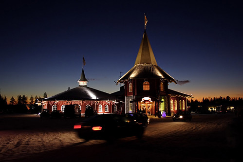
Image from
Flickr is by
Robert Parviainen
Arctic Circle line cuts through Santa's Office.
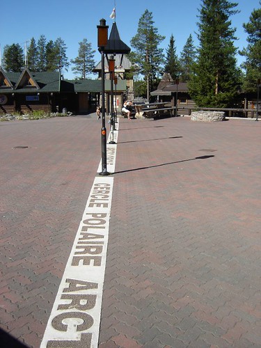
Image from
Flickr
is by
Emiliano Marin
View location in
Google Maps and Street View
Route 945, Kemijärvi, Finland
A small sign;

Image Source:
Google Street View
Route 9452, Soumu, Finland
Suomu is an alpine ski resort in the Lapland province of Finland, near the municipality of Kemijärvi. The resort is sometimes known as the Arctic Circle Ski resort because of its close proximity to the Arctic Circle.

Image from
Panoramio is by
UL
View location in
Google Maps
Hwy E-63 Near, Soumu, Finland

Image Source:
Google Street View
A snowman sculpture nearby

Image from
Panoramio is by
StanisławGoś
View location in
Google Maps and Street View
Hwy E105/M18, Loukhsky, Karelia, Russia

Image from
Panoramio is by
crivoruchko
View location in
Google Maps and Street View
Unknown Road, Umba, Tersky, Murmansk Oblast, Russia

Image from
Panoramio is by
SmEsHaRiK
View location in
Google Maps
Unknown Road, Usinsk, Komi Republic, Russia

Image from
Panoramio is by
iSonnik
View location in
Google Maps
Salekhard, Russia
Salekhard is the largest town located on Arctic Circle and keeping up with this reputation, it has a big monument to the Circle. The Arch runs along the circle and the two tall towers are on north and south of the line. For some reason one of the tower is shorter than the other.

Image from
Panoramio is by
dimamol
View location in
Google Maps
Unknown place near Zapolyarnyy, Nadymsky District, Russia
A nice looking monument somewhere in Zapolyarnyy (Заполярный); an urban-type settlement in Nadymsky District of Yamalo-Nenets Autonomous Okrug.

Image from
Panoramio is by
vvg1958
View location in
Google Maps
Unknown Road near Novy Urengoy, Yamal-Nenets, Russia
Found identical pair of Arctic Circle Monuments at 4 different locations. I feel that due to poor imagery these were not correctly located in Panoramio. I was also in dilemma where to placemark these on GE. One of the Panoramio image
shows a monument on Novy Urengoy - Yamburg
Route. I have therefore placed the GE placemarker at this location (I call it
Location #2) and if needed, will relocate the placemarker, as and when I get more information or when the imagery of this
area is updated and the monuments can be seen in GE.

Image from
Panoramio is by
dimamol
Above image is at Location #2, and identical monuments can be seen at
Location #1 (18.5 km East)
and
Location #4 (30.5 Km
West) from current location.

Above image is at Location #2, and identical monuments can be seen at
Location #1 (18.5 km East)
and
Location #3 (21 Km
West) from current location.
View likely location in
Google Maps
Unknown Road near Novozapolyarny, Tazovsky District, Yamalo-Nenets, Russia
Three monuments at same place;

Image from
Panoramio is by
realsasha

Image from
Panoramio is
by
Savon
Yuriy
The above two monuments are on left and right side of the road at the same
location. While the third one, below is probably a bit away.

Image from
Panoramio is by
Vghik
View location in
Google Maps
Intersection of Anti-meridian (180° East/West), Russia
Instead of a major sign or monument at the intersection of
Anti-meridian line with Arctic Circle, a nondescript and decaying sign.
As per the photographer ".... intersection is two
kilometers from the symbol up on the mountain". The title of the image
says "Условное обозначение 180 меридиан", meaning "Symbol 180 Meridian".

Image from
Panoramio is by
Александр
Биушкин
View location in
Google Maps
Lultin Road, Near Ozërnyy, Russia

Image from
Panoramio is by
Шабанов
View location in
Google Maps
Dalton Highway, Alaska, USA
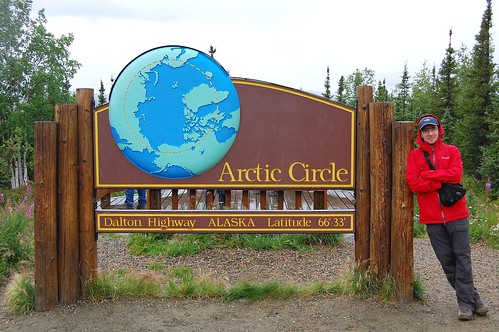
Image from
Flickr
is by
Ilya Katsnelson
View location in
Google Maps
Fort Yukon, Alaska, USA
No major Monument/Sign at Fort Yukon, instead two ordinary
signs.
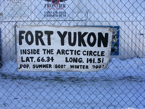
Image from
Flickr is
by
Kirk Crawford

Image from
Panoramio is by
gkl
View location in
Google Maps
Dempster Highway, Yukon Territory, Canada
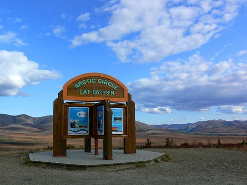
Image from
Flickr
is by
Tania Liu
View location in
Google Maps
Repulse Bay (Naujaat), Canada

Image from
Panoramio is
by
lchernenko
View location in
Google Maps
Grimsey Airport, Grimsey Island, Iceland

Image from
Flickr is by
William Wallace

Image from
Flickr
is by
aleph78
View location in
Google Maps
Arctic Henge, Raufarhöfn, Iceland
Although the Arctic Circle doesn't pass through the main land Iceland, however a
huge monument called "Arctic Henge" is being built in its Northern town
Raufarhöfn, which lies only a few kilometres below the Arctic Circle.
Arctic Henge based on Icelandic mythology and poetry, is planned to have several
concentric circles made of stones. When completed its outer circle will have a
huge diameter of 52 metres (170 feet). At the centre is a huge 4 way arch and
four gates corresponding to the four seasons, and several other symbols.
In mythological terms The Henge will capture the energy of the Midnight Sun at
the Arctic Circle. In words of
clonehenge.com;
"(It) is being built to mark and catch the sun and other heavenly bodies as
they move around the sky. Interweaving science, mythology, geography, and
tourism, the project promises to be beautiful, educational, poetic and even
transforming, a chance to feel the connection between a point on the surface of
our planet and the light-bearing actors in the dramas of the heavens. Will it
evoke for moderns what Stonehenge must have evoked for those who visited it at
its height?"
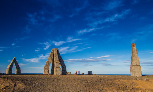
Image from
Flickr
is by
Ólafur Gísli Agnarsson

Image from
Panoramio is by
Fritz
Weinauer
Sun seen through the north gate - image taken from the south.

Image from
Facebook - Arctic Henge's Photos is by Erlingur Thoroddsen
View location in
Google Maps
____________________________
View All locations in Google Earth -
Download kmz file.
Read more...


