


Giant Hands Around The World - May 2024 Update
Another major addition to my collection of "Giant Hands Around The World".
A total of 117 118 new hands at 83 locations have been added in this addition. With this
addition, the collection now includes more than 575 locations. The
actual number of hands is 650+, as some locations have more than one hand.
The newly found location and hands therein are:
- Hands Cradling An Open Chest, Cling Lounge & Bar, Civil Lives, New Delhi, India.
- Hands Memorial to Venmani Martyrs, Kizhavenmani, Tamil Nadu, India.
- Giant Hand, Kintoor, Baraulia, Barabanki, UP, India.
- Giant Hand, Srogo Fruit Farm, Tawanganom, Magetan, East Java, Indonesia.
- Hands of Choice, Safed, Israel.
- Four Hands at Sanno Bridge, Imizu, Toyama, Japan.
- Giant Hand, Gap Farming Resort, Davao City, Philippines.
- Boy Scout Monument, Los Banos, Laguna, Philippines.
- Le Pouce de César, Souk Waqif, Doha, Qatar.
- Hand at Chin Pao San Cemetery, New Taipei, Taiwan.
- Giant Hands, Yassıada Island, Turkey.
- Hands, Prehistoric Cave Paintings, Ngula (Jar Island), Australia.
- White Hands, Centennial Park Cemetery, Pasadena, Australia.
- Giant White Hand Holding A Streamer, Millicent, SA, Australia.
- Big Thumbs Up, Scottsdale, TAS, Australia.
- Hand Holding Pears, Wellen, Flanders, Belgium.
- Pair of White Hands, Lebbeke, Belgium.
- Two Clenched Fists Holding Torches, Buzludzha, Kazanluk, Bulgaria.
- Le Pouce de César, Humlebæk, Denmark.
- Butt Im Griff, Sønderborg, Denmark.
- Le Pouce de César, Île Seguin, Boulogne-Billancourt, France.
- Hands Holding a Sphere, Couëron, France.
- Two Fingers Victory Sign, Épinal, France.
- Hands Imprints on Transparent Sphere, Le Havre, France.
- Hands Holding Globe, Loon-Plage, France.
- Pair Of Cupped Hands, Montreuil, France.
- Le Pouce de César, Nice, France.
- Le Pouce de César, The Centre Pompidou, Paris, France.
- Hands Joined in Prayer, Rochefort-du-Gard, France.
- Hands Protecting Eiffel Tower, Eu, Seine-Maritime, France.
- Butt Im Griff, Gildehaus, Bad Bentheim, Germany.
- Butt Im Griff, Behlendorf, Germany.
- Pair of Overlapping Hands, Berlin, Germany.
- Butt Im Griff, Göttingen, Germany.
- Butt Im Griff, Günter Grass-Haus, Lübeck, Germany.
- Sculpture Of A Violinist, National Opera & Ballet, Amsterdam, Holland.
- Giant Hands Holding a Globe, Leusden, Holland.
- Hands Holding a Sling, Leusden, Holland.
- Hand of the Manx Giant, Isle of Man.
- Pair of Hands Protecting Flowering Shrub, Bagnara, Calabra, Calabria, Italy.
- Two Hands and a Ring, Obninsk, Russia.
- Hands Protecting Trees, Yekaterinburg, Russia.
- Hand Between Sky and Earth, Allai, Sardinia.
- Three Fists Monument, Memorial Park Bubanj, Nis, Serbia.
- Pair of Hands, Puente de Trabajo Digne, Barcelona, Spain.
- Hand Holding A Rail, Barcelona, Spain.
- Hand Holding Grapes, Briones, Spain.
- Captive Hands of the Christ of Medinaceli, Ceuta, Spain.
- Hand of God, Quinn Creations, Gavà, Spain.
- Hands Supporting A Tree, Quinn Creations, Gavà, Spain.
- Clasped Hands, Granollers, Spain.
- Clasped Hands, Rancate, Mendrisio, Switzerland.
- Giant Waymarker Hand, Argyll and Bute, UK.
- Canalside Carving, Wharf Bridge, Aldershot, England, UK.
- Tribute to Indigenous Children, Nanaimo, BC, Canada.
- Giant Hand, El Pósito Viewpoint, Chiapas Viewpoint, Mexico.
- Two Hands holding Wooden Ball on a Stick, Mexico City, Mexico.
- Giant Hand Shaped Chair, Cuauhtémoc, México City, Mexico.
- Giant Hands, Jojutla, Morelos, Mexico.
- Hands at Entrance, Vagalume, Tulum, Quintana Roo, Mexico.
- Hands Supporting Walkway Over A Pool, Vagalume, Tulum, Quintana Roo, Mexico.
- Pair of White Hands, Vagalume, Tulum, Quintana Roo, Mexico.
- Hands Cradling An Open Chest, Ven a la Luz Sculpture Park, Tulum, Quintana Roo, Mexico.
- Hand Lying on the Ground, Ven a la Luz Sculpture Park, Tulum, Quintana Roo, Mexico.
- Pair of White Hands, Ven a la Luz Sculpture Park, Tulum, Quintana Roo, Mexico.
- Giant Hand, Maopochtliii Viewpoint, San Nicolas de los Montes, San Luis Potosi, Mexico.
- Hands of Francis of Assisi Viewpoint, Real de Catorce, San Luis Potosí, Mexico.
- Giant Wooden Hand, Maven Hotel, Denver, CO, USA.
- Large Hands Fountain, Holiday World, Santa Claus, IN, USA.
- Pair of Hands, Old School Gallery, El Morro, NM, USA.
- Hook 'Em Horns Tree, Austin, TX, USA.
- Giant Robotic Hand, Johnson City, TX, USA.
- Le Pouce de César, Hirshhorn Sculpture Garden, Washington (DC), USA.
- Two Intertwined Hands, La Plata, Buenos Aires Province, Argentina.
- Wooden Hand Holding A Flaming Torch, Colón, Argentina.
- Cave of the Hands, Santa Cruz, Argentina.
- Hand Sculptures at Jardim das Esculturas, São João dos Mellos, RS, Brazil.
- Giant Hands along the Roads to Sculpture Garden, RS, Brazil.
- Giant Hands Supporting the Roof and Pillars of Hotel Lobby, Bogotá, Colombia.
- Giant's Hand Viewpoint, Gigante, Huila, Colombia.
- Giant Hand Holding A Huge Sphere, Tocancipá, Colombia.
- Hand Pointing to Sky, Quesada, Alajuela, Costa Rica.
- Giant Hands at Nosara Beach Hotel, Nosara, Costa Rica.
Given below are brief details of newly added hands, along with images and location:
Hands Cradling An Open Chest, Cling Lounge & Bar, Civil Lines, New Delhi, India.
An eye-catching sculpture in the Cling lounge welcomes the guests inside with an open heart.
A sculpture with a similar design known as Ven a la Luz (meaning 'Come to the light') is also at the Sculpture Park in Tulum, Quintana Roo, Mexico.
Image from Google Maps
is by
sanjeev kapoor

Hands Memorial to Venmani Martyrs, Kizhavenmani, Tamil Nadu, India.
The memorial in Kizhavenmani (Venmani village), Nagapattinam, Tamil Nadu, India, commemorates the 44 Dalit (low-caste) labourers who were brutally massacred on December 25, 1968. The memorial consists of 44 granite pillars, symbolising the victims. Each pillar is adorned with a clenched raised fist, and the pillars encircle a large museum building, preserving the memory of this tragic event.
Image from Google Maps is by
Balamurugan
Ramalingam

Source of information: Wikipedia
Giant Hand, Kintoor, Baraulia, Barabanki, UP, India.
A giant hand with the forefinger holding a disc is located near a baobab tree in the village of Kintoor, Baraulia, Barabanki, India. The baobab trees are native to Sub-Saharan Africa, and their presence in India, especially in the fertile Indo-Gangetic Plain, is a very rare phenomenon. The tree is about 800 years old, and its presence in this region is a mystery. Because of its rarity, the tree is considered sacred by the Hindus, and they worship it. The tree, locally known as the Parijaat tree, is associated with the Hindu god Lord Krishna.
The disc probably represents the mythological flying disc, which Lord Krishna used as a weapon while fighting the evil forces.
Image from Google Maps
is by Shesh
Mani

Google Maps: Likely location, as the hand is not visible in Google Maps or in Google Street View.
Giant Hand, Srogo Fruit Farm, Tawanganom, Magetan, East Java, Indonesia.
The fruit garden has been developed as a nature tourism spot where one can enjoy 22 types of fruits. Reportedly, there are about 830 fruit trees.
Image from Google Maps is by
Mulyono

Source of information: beritatrends.co.id
The Hands of Choice, Safed, Israel.
"The Hands of Choice," an artwork by Jerusalem sculptor Sam Philipe, features a pair of hands cradling a 3-dimensional Star of David. On each facet of the star, the names of 400 Jews who saved other Jews are etched in both Hebrew and English.
Image from Google Maps
is by Ran
Shitirit

Google Maps (Not visible in Google Maps but the location is marked on the map.)
Source of information: The Times of Israel Blog by Jerry Klinger
Four Hands at Sanno Bridge, Imizu, Toyama, Japan.
The Bridge of Hands, formerly Sanno Bridge, is a unique bridge with four marble hand sculptures, one at each corner of the bridge.
Image from Google Maps
is by 高橋裕里香

Image from Google Maps
is by すみかつ

Image from Google Maps
is by tomba

Image from Google Maps
is by すみかつ

Image from Google Maps
is by 湯とり世代

Source of information: takeda.noor.jp
Giant Hand, Gap Farming Resort, Davao City, Philippines.
A large hand of a buried giant rising from the ground.
Image from Google Maps
is by Surya
Durai

Google Maps. Likely location, as the hand is not visible in Google Maps or in Google Street View.
Boy Scout Monument, Los Banos, Laguna, Philippines.
Located at the Campground of Boy Scouts
Image from Google Maps
is by Fong
Kah Chun

Le Pouce de César, Souk Waqif, Doha, Qatar.
Le Pouce (The Thumb) is a classic sculpture by the famous sculptor César Baldaccini. Modelled after his own thumb, it depicts, in detail, the fingerprint and skin wrinkles. Several replicas of this famous sculpture have been made and are installed at various locations around the world.
This sculpture was installed to commemorate the victory of the Qatari football team at the 2019 Asian Cup.
Image from Google Maps
is by Mia A

Source of information: timeoutdoha.com
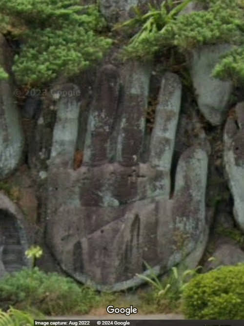
Hand at Chin Pao San Cemetery, New Taipei City, Taiwan.
A large hand amongst many faces, a foot, and busts of Buddha carved into the rock at the cemetery.
Image Source: Google Street
View
Giant Hands, Yassıada Island, Turkey.
Yassıada, a very small island in the Sea of Marmara, was the venue of the trials of members of the former ruling Democrat Party (DP), following the military coup of May 27, 1960. Several members of the DP were sentenced to death. The island is now officially called Democracy and Freedom Island.
There are two pairs of giant hands located on the island as part of the museum established in memory of all those who were who were tried there.
One pair of hands is holding a chain, while the other pair of hands is holding a blindfolded face with an open book lying on the ground.
Image from Google Maps
is by
Hatice AYDIN
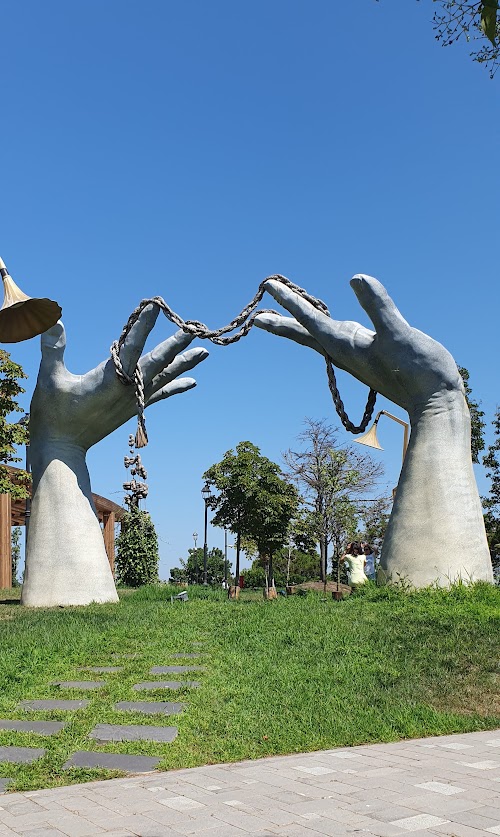
Image from Google Maps
is by Heba

Google Maps. (Likely location somewhere in the green area near the museum. The hands are not visible in Google Maps or in Google Street View.)
Hands, Prehistoric Cave Paintings, Ngula (Jar Island), Australia.
The prehistoric cave paintings at Ngula (Jar Island), Kimberley Coast, WA, Australia, known as Gwion or Bradshaw paintings, are estimated to be around 15,000 to 20,000 years old.
These are, therefore, the oldest works of art in this collection.
Image Source: Google Street
View (Photosphere) by
Aspen
Travel Advisors 970-315-2226.

Source of information: zayahworld.com
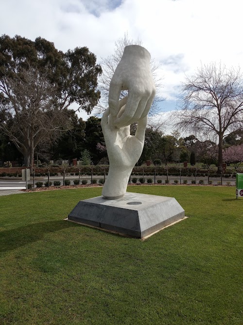
White Hands, Centennial Park Cemetery, Pasadena, Australia.
Called "Connections," the 4 metre-high sculpture by Karl Meyer at Centennial Park Cemetery was unveiled in December 2018. It is softly lit at night.
Image from Google Maps
is by Oz
Guy
Source of information: adelaidenow.com.au
Giant White Hand Holding A Streamer, Millicent, SA, Australia.
The artwork was installed in September 2021 at the corner of Williams Road and Ridge Terrace.
Image Source: Google Street
View

Source of information: borderwatch.com.au
Big Thumbs Up, Scottsdale, TAS, Australia.
A wooden hand on Kings Street (A3) with the sign "G'day Mate, Welcome to Scottsdale."
Image from Google Maps
is by
Eugene Foo

Hand Holding Pears, Wellen, Flanders, Belgium.
Located at a roundabout at the intersection of Bloemenstraat and Zonneveldweg.
Image Source: Google Street
View

Pair of White Hands, Lebbeke, Belgium.
The White Hands Memorial in Lebbeke, Belgium, is a poignant tribute to the civilians who were executed en masse by the Germans during World War I. The memorial, an artwork by local sculptor Wilfried Jacops, commissioned in 2014, is located on a roundabout and symbolises peace and remembrance.
Image from Google Maps
is by Hans
De Middeleer

A smaller version of the sculptor has been installed at the Rest Area on Hof-ter-Varentstraat.
Image from Google Maps
is by
Larisa L.

Source of information: tracesofwar.com
Two Clenched Fists Holding Torches, Buzludzha, Kazanluk, Bulgaria.
The sculpture represents the friendly relationship that existed between Bulgaria and the erstwhile USSR.

Image from Flickr
is by Leon Hart
Le Pouce de César, Humlebæk, Denmark.
Le Pouce (The Thumb) is a classic sculpture by the famous sculptor César Baldaccini. Modelled after his own thumb, it depicts, in detail, the fingerprint and skin wrinkles. Several replicas of this famous sculpture have been made and are installed at various locations around the world.
This sculpture is located at the Louisiana Museum of Modern Art, Humlebæk, Denmark.
Image from Google Maps
is by
Natalia Font

Google Maps. Being indoor, it is not visible in Google Maps satellite imagery.
"Butt Im Griff", Sønderborg, Denmark.
Der Butt im Griff is a bronze sculpture by the artist Günter Grass. The sculpture is 2.3 metres high and shows a hand holding a flounder fish, which symbolises experience in life and wisdom.
There are many replicas of this sculpture. This one on the shores of the Alssund Straits at Sønder Havnegade Street, Sønderborg, Denmark, is one of the several that are included in this collection.

Image from Flickr
is by Arne List
Le Pouce de César, Île Seguin, Boulogne-Billancourt, France.
Le Pouce (The Thumb) is a classic sculpture by the famous sculptor César Baldaccini. Modelled after his own thumb, it depicts, in detail, the fingerprint and skin wrinkles. Several replicas of this famous sculpture have been made and are installed at various locations around the world.
This one is located in front of the Seine Musicale building, Île Seguin (Seguin Island), an island on the Seine river in the west suburbs of Paris. The 6-metre-tall sculpture was earlier installed at Collège Romain-Rolland, Le Plessis-Robinson, and was relocated here in 1998.
Image from Google Maps
is by
Delphine

Source: French Wikipedia
Hands Holding a Sphere, Couëron, France.
Located at the intersection of Bd François Blancho with Rue Alexandre Olivier, Couëron.
Image from Google Maps
is by
Goreti Fernandes

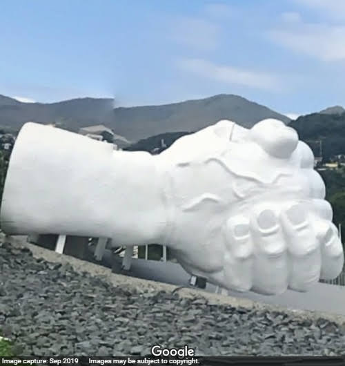
Two Fingers Victory Sign, Épinal, France.
Located on Rue des Minimes, Épinal, France, the sculpture by César is called Liberté. Made of bronze, the sculpture is 6.5 metres high. It was unveiled in 1989 on the occasion of the bicentenary of the 1789 French Revolution.
Image from Google Maps is by
Lolo
Laurent

Google Street View (Sept. 2019). It can be barely visualised at the far end, in front of the white car, but it can be clearly seen in this Google Street View (Photosphere).
Source of information: atlasmuseum.net
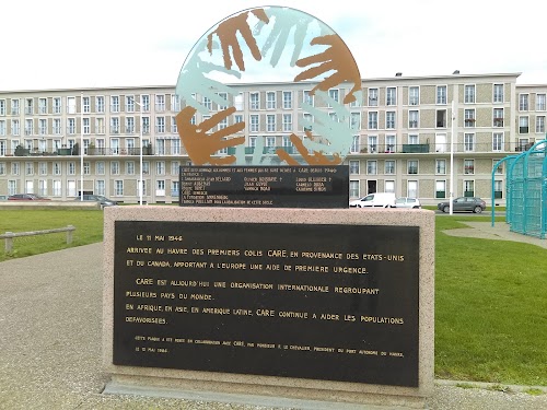
Hands Imprints on Transparent Sphere, Le Havre, France.
Located on Boulevard Clemenceau, the monument's design is based on the logo of CARE International, an international NGO.
Image from Google Maps
is by G P
Hapitan
Hands Holding Globe, Loon-Plage, France.
Located on Rdpt de la 5ème République (5th Republic Roundabout), Loon-Plage, Hauts-de-France.
Image Source: Google Street
View

Pair Of Cupped Hands, Montreuil, France.
The mural 'La Paix' (Peace), created by the artist Espion, is situated on Rue Edouard Vaillant in Montreuil.
Image Source: Google Street
View

Source of information: streetartcities.com
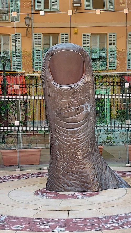
Le Pouce de César, Nice, France.
Le Pouce (The Thumb) is a classic sculpture by the famous sculptor César Baldaccini. Modelled after his own thumb, it depicts, in detail, the fingerprint and skin wrinkles. Several replicas of this famous sculpture have been made and are installed at various locations around the world.
This sculpture created in 1963 is located at the entrance to Nice City Hall (Hotel de Ville).
Image from Google Maps
is by
Hanspeter Lutz
Le Pouce de César, The Centre Pompidou, Paris, France.
Le Pouce (The Thumb) is a classic sculpture by the famous sculptor César Baldaccini. Modelled after his own thumb, it depicts, in detail, the fingerprint and skin wrinkles. Several replicas of this famous sculpture have been made and are installed at various locations around the world.
One such sculpture was installed in front of the Centre Pompidou, but its installation date and current whereabouts are a mystery.
As per atlasmuseum.net a golden coloured thumb was installed in 1965 in front of the Centre Pompidou
However as per sortiraparis.com a monumental 6-metre-high gilded bronze Thumb was installed on November 28, 2017 on the piazza, Place Georges Pompidou, on the occasion of the "César retrospective," which was held at the centre from 13th December 2017 to 26th March 2018.
Various pictures on sortiraparis.com and in Google Street View (Photosphere) show a large Thumb in a hall and also a pair of Thumbs in a glass cubicle inside the Centre.
The Street Views of the outside taken by Google Car don't show any Thumb but third party Google Views (photospheres) do show the Thumb at the outside. Perhaps all the Thumbs were temporarily installed at the centre.
Image from Google Maps
is by
Daniele Nicola Dinami


Image from Flickr
is Jean-Pierre Dalbéra
Image Source: Google Street
View (Photosphere) by
Jean-Marc
Perfetti

Google Street View (Photosphere) outside view.
Google Street View ((Photosphere) inside view.
Hands Joined in Prayer, Rochefort-du-Gard, France.
Located in front of the Saint-Bardulphe Church, Rue de l'Église, Rochefort-du-Gard, France.
Created in the early 1980s by Bruno Parizat, it is among his numerous artworks located in the town.
Image Source: Google Street
View

Hands Protecting Eiffel Tower, Eu, Seine-Maritime, France.
A fresco painted by artist Johann Grenier as a tribute to the victims of the Paris attacks of November 13, 2015.
Image Source: Google Street
View

Source of information: france3-regions.francetvinfo.fr
"Butt Im Griff", Gildehaus, Bad Bentheim, Germany.
Der Butt im Griff is a bronze sculpture by the artist Günter Grass. The sculpture is 2.3 metres high and shows a hand holding a flounder fish, which symbolises experience in life and wisdom.
There are many replicas of this sculpture. This one in front of the Otto-Pankok Museum, Neuer Weg, Gildehaus, Bad Bentheim is one of the several that are included in this collection.
Image from Google Maps is by
Heidi Drogt

"Butt Im Griff", Behlendorf, Germany.
Der Butt im Griff is a bronze sculpture by the artist Günter Grass. The sculpture is 2.3 metres high and shows a hand holding a flounder fish, which symbolises experience in life and wisdom.
There are many replicas of this sculpture. This one in front of Brinkhuus, Gemeinde Behlendorf, Am Brink, Behlendorf, where the artist's stayed for many years, is one of the several that are included in this collection.
Image from Google Maps
is by
Rainer Otte

Source of information: sh-kunst.de
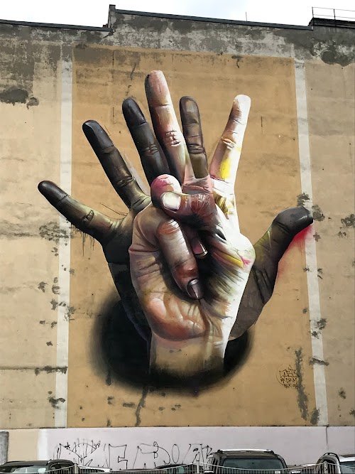
Pair of Overlapping Hands, Berlin, Germany.
The mural titled "Unter der Hand" (Under the Hand) at the corner of Brückenstraße and Köpenicker Strasse, Kreuzberg district, is an artwork by artist Case MaClaim.
Image from Google Maps
is by
Chandler L.
Source of information: street-art-avenue.com
"Butt Im Griff", Göttingen, Germany.
Der Butt im Griff is a bronze sculpture by the artist Günter Grass. The sculpture is 2.3 metres high and shows a hand holding a flounder fish, which symbolises experience in life and wisdom.
There are many replicas of this sculpture, and this one at Papendiek Street, Göttingen, is one of the several that are included in this collection.

Image from
deutscheecke.blogspot.com is by
J. Luis García
"Butt Im Griff", Günter Grass-Haus, Lübeck, Germany.
Der Butt im Griff is a bronze sculpture by the artist Günter Grass. The sculpture is 2.3 metres high and shows a hand holding a flounder fish, which symbolises experience in life and wisdom.
There are many replicas of this sculpture, and this one at Günter Grass-Haus, Glockengießerstraße, Lübeck, is one of the several that are included in this collection.
Image from Google Maps is by
Christel
Dönitz

Source of information: sh-kunst.de
Sculpture Of A Violinist, National Opera & Ballet, Amsterdam, Holland.
The head and a hand holding a violin bursting through the tiled floor of Amsterdam's National Opera & Ballet is an eye-catching artwork created by an unknown artist who is known for anonymously installing various artworks in public spaces in Amsterdam under the cover of night.

Image from
Flickr
is by Chris 861
Not visible in Google Street View.
Source of information: heavenly-holland.com
Giant Hands Holding a Globe, Leusden, Holland.
Two huge hands holding a big globe entitled "You Are The World" is an artwork created by Lorenzo Quinn and installed at the premises of AFAS Software.
Image from Google Maps
is by magic
chocolate

View from the front.
Image from Google Maps
is by Hans
Driesen

Source of information: afas.nl
Hands Holding a Sling, Leusden, Holland.
Called "Stop Playing" this sculpture, an artwork by Lorenzo Quinn, is located in the courtyard garden at the AFAS Software.
Image from Google Maps
is by Robin
Eype

Goggle Maps. Likely location, as the hand is not visible in Google Maps or in Google Street View.
Source of information: afas.nl
Hand of the Manx Giant, Isle of Man.
Arthur Caley, popularly known as the Manx Giant, was born in Sulby, on the Isle of Man, in 1824. He was a giant of a man, standing 2.41 metres (7 feet 11 inches) tall and weighing more than 280 kg (400 lbs). He was probably the tallest man in the world during his lifetime.
His life was surrounded by mystery. He reportedly died in Paris in 1853, but later, around 1859, he turned up in New York in P.T. Barnum's show under the name of Colonel Routh Goshen, the Arabian Giant.
During his early years, he used to work in Rose Cottage in Regaby, near Sulby, where a cast of his hand is on display at the gate pillar. The height of the middle finger from the ground is exactly 2.41 metres, the same height as the Manx Giant.
Image Source: geograph.org.uk

Source of information: BBC News / Wikipedia
Pair of Hands Protecting Flowering Shrub, Bagnara, Calabra, Calabria, Italy.
Near the Ponte di Caravilla.
Image Source: Google Street
View

Two Hands and a Ring, Obninsk, Russia.
Located outside Salon Brakosochetaniya, a wedding hall, it shows two hands, one masculine and the other feminine, with a ring in the background.
Image from Google Maps is by
Сергей
Лапаев

Hands Protecting Trees, Yekaterinburg, Russia.
Somewhere on Ulitsa Pushkina, Yekaterinburg, Russia.
Image Source: Google Street
View

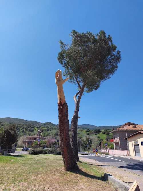
Hand Between Sky and Earth, Allai, Sardinia.
Artist Simon O’Rourke has beautifully converted an old decaying tree into a work of art, an outstretched hand reaching to the sky. The sculpture is called "A Hand Between Sky and Earth".
Image from Google Maps is by
Carmen
Oggiano
Source of information: Website of artist Simon O’Rourke - treecarving.co.uk
Three Fists Monument, Memorial Park Bubanj, Nis, Serbia.
The Three Fists Monument in Bubanj Memorial Park in Niš commemorates the shooting and execution of over 10,000 citizens of Niš and people from other regions of Serbia by the German troops. It consists of three concrete obelisks in abstract form, shaped like raised hands with clenched fists of varying sizes, representing men, women, and children who defied the enemy.
Image from Google Maps
is by
Stanislava Smiljković

Source of information: Wikipedia
Hand Holding A Rail, Barcelona, Spain.
An artwork by Josep Ricart Maymir, the sculpture titled Cooperativa de Tramvies is a tribute to the tramway system of Barcelona.

Image from
Wikimedia Commons is by DagafeSQV
Source of information: bcnroc.ajuntament.barcelona.cat
Pair of Hands, Puente de Trabajo Digne, Barcelona, Spain.
A sculpture titled Matrimoni (wedding) by artist Josep Ricart Maymir.

Image from
Wikimedia Commons is by Ismael March
Hand Holding Grapes, Briones, Spain.
A large hand holding grapes emerges from the wall of the Vivanco Museum of Wine Culture.
Image from Google Maps
is by
Javier Alguacil

Captive Hands of the Christ of Medinaceli, Ceuta, Spain.
Two hands bound by rope symbolise the captive hands of the "Cristo del Medinaceli" (Christ of Medinaceli). These bronze hands, emerging from the walls, are located within a fountain at the intersection of Avenida España and Avenida Otero and are an artwork by the Pedrajas brothers.
Image from Google Maps is by
C. Antonio
González

Source of information: ceutaturistica.com
Hand of God, Quinn Creations, Gavà, Spain.
A replica of the famous sculpture "Hand of God" at the workshop of Lorenzo Quinn. It is possible that this may be the original and that others elsewhere could be replicas.
Image from Google Maps
is by
Mireia

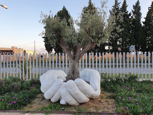
Hands Supporting A Tree, Quinn Creations, Gavà, Spain.
Another pair of hands at the workshop of the famous sculptor Lorenzo Quinn.
Image from Google Maps
is by
Francisco Gárate
Clasped Hands, Granollers, Spain.
The sculpture commemorates the title awarded to the city in recognition of its efforts to promote Sardana, which is a traditional Catalan dance.
The sculpture inaugurated in 1976 is the work of artist Josep Ricart Maymir. It is located in Parc Torras Villà and depicts two hands holding each other, as in the dance of the Sardana.
Image from Google Maps
is by Ramon
Blanco

Google Maps Likely location, as the hands are not visible in Google Maps or in Google Street View.
Source of information: poblesdecatalunya.cat
Clasped Hands, Rancate, Mendrisio, Switzerland.
An artwork by artists Judith Holstein and Gianni Rodenhäuser, located on a roundabout on the Via Antonio Rinaldi intersection with Via Pizzolo in Rancate.
Image Source: Google Street
View (Photosphere) by
Salvatore
Sinopoli
Source of information: kunstimkreisverkehr.de
Giant Waymarker Hand, Argyll and Bute, UK.
A large carved wooden hand points to Ardfern at the T-off from A816 near Kintraw. Created by artist Robert Coiait, it is 7 metres (22 feet) long and 2.4 metres (7.8 feet) high.
Image source: geograph.org.uk

Source of information: saatchiart.com
Canalside Carving, Wharf Bridge, Aldershot, England, UK.
A wooden sculpture beside the Basingstoke Canal Tow Path, near Wharf Bridge, Farnborough Road, Aldershot, England, UK.
Image Source:
geograph.org.uk

Tribute to Indigenous Children, Nanaimo, BC, Canada.
A large number of orange handprints on the dark wall symbolise the tragic discovery of Indigenous children's remains at former residential schools in Canada. The artwork by artist Lauren Semple is located on a wall on Wallace St. opposite City Hall.
Image Source: Google Street
View.

The picture shows only a small portion of the hands on the wall. A full view can be seen at the above Google Street View link.
Source of information: The Wave 102.3 FM
Giant Hand, El Pósito Viewpoint, Chiapas Viewpoint Mexico.
A viewpoint designed as a giant hand overlooking the Chiapas forest in Córdova Matasanos, Unión Juárez, Mexico. The hand rises to a height of 17 metres.
Image from Google Maps
is by
Adolfo Cruz

Google Maps The hand is barely visible in the satellite imagery.
Source of information: Mexico Desconocido
Two Hands holding Wooden Ball on a Stick, Mexico City, Mexico.
Located in the Museum of Ancient Mexican Toys (Museo del Juguete Antiguo México), Cuauhtémoc, Ciudad de México, Mexico.
Image from Google Maps
is by
Thunderxk

Giant Hand Shaped Chair, Cuauhtémoc, México City, Mexico.
Located on the roof of a shop at 40 Veracruz Street, Roma Nte., Cuauhtémoc, it was created by artist Pedro Friedeberg.
Image from Google Maps
is by
Alfredo perezdetejada

Source of information: mxcity.mx
Giant Hands, Jojutla, Morelos, Mexico.
A large hand comforting (or supporting) another hand is a memorial to the devastation of the town and the lives lost at Jojutla, Morelos, due to the September 2017 earthquake.
Image from Google Maps
is by
Pineda Art (PinedaArt)

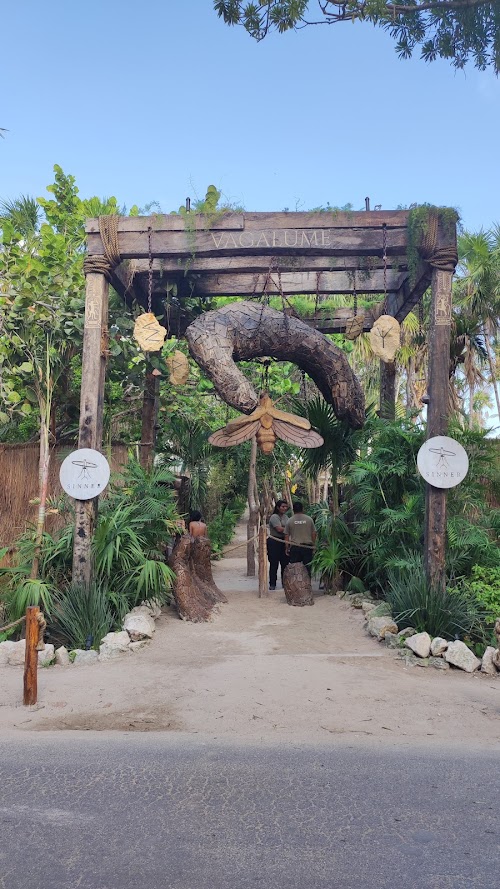
Hands at Entrance, Vagalume, Tulum, Quintana Roo, Mexico.
Two wooden hands, one hanging from the top and the other buried in the ground at the entrance portal of the Vagalume Tulum.
Image from Google Maps
is by
Javier Alegre
Hands Supporting Walkway Over A Pool, Vagalume, Quintana Roo, Mexico.
Located at Vagalume Tulum at the Tulum Beach.
Image from Google Maps
is by
Monica Sanchez

Pair of White Hands, Vagalume, Tulum, Quintana Roo, Mexico.
Image from Google Maps
is by
Aurélien Miserey

Google Maps Likely location, as these hands are not visible in Google Maps or in Google Street View.
Hands Cradling An Open Chest, Tulum, Quintana Roo, Mexico.
An eye-catching sculpture in Tulum called Ven a la Luz (meaning 'Come to the light') depicts two hands framing the open ribcage of a woman. An artwork by South African artist Daniel Popper, it was originally displayed at the Art With Me Tulum Festival in 2018. Later on, it was moved to the Ahau Tulum Resort, and finally, in late 2021, it was relocated as an entrance to a newly created sculpture park adjacent to the Ahau Tulum Resort. The 10-metre (33-foot) tall wooden sculpture is a popular spot for social media posts and a selfie point, and usually there is a long queue for taking pictures there.
A sculpture with a similar basic design but white in colour is also at the Cling Lounge & Bar, New Delhi, India.
Image from Google Maps
is by D.E.
Parks

Google Street View (Before it was moved to new location. Current location not visible in Google Maps or in Google Street View.)
Source of information: tulumtravelsecrets.com
Hand Lying on the Ground, Ven a la Luz Sculpture Park, Tulum, Quintana Roo, Mexico.
Image from Google Maps
is by
Mercedes Sarduy

The exact location couldn't be ascertained, as the hand is not visible in Google Maps or in Google Street View.
Pair of White Hands, Ven a la Luz Sculpture Park, Tulum, Quintana Roo, Mexico.
Image from Google Maps
is by
Damien Zimmerman

The exact location couldn't be ascertained, as the hands are not visible in Google Maps or in Google Street View.
Giant Hand, Maopochtliii Viewpoint, San Nicolas de los Montes, San Luis Potosi, Mexico.
A viewpoint shaped like a giant hand, overlooking the stream leading to San Nicolas de los Montes Waterfall.
Image from Google Maps
is by
Montse Castillo

Google Maps (Not visible in Google Maps but the location is marked on the map.)
Source of information: Mexico Desconocido
Hands of Francis of Assisi Viewpoint, Real de Catorce, San Luis Potosí, Mexico.
Two hand-shaped viewpoints, modelled after the hands of Saint Francis of Assisi, the patron saint of the town of Real de Catorce. The viewpoint offers a scenic view of the mountain and the valley.
Image from Google Maps
is by Eder
Dodero

Image from Google Maps
is by Wuera
Null

Source of information: sanluis.eluniversal.com.mx. The website has some good pictures of the giant hands.
Giant Wooden Hand, Maven Hotel, Denver, CO, USA.
A large 3-metre (10-foot) wooden hand hangs from the ceiling of the hotel lobby. The hand, an artwork by Colorado Springs' artist Andrew Ramiro Tirado, weighs about 227 kg (500 lbs).
Image from Google Maps
is by Susan
Peele

Source of information: denver.org
Large Hands Fountain, Holiday World, Santa Claus, IN, USA.
This fountain with large hands, known as the Applause Fountain, commemorates Holiday World winning the international "Applause Award", an industry award given out every two years to the best amusement parks world wide. The hands are the larger replica of the actual trophy won by them.

Image from Flickr
is by Heather Kendrick. Permission to use the image is thankfully acknowledged.
Source of information: Flickr / Wikipedia
Pair of Hands, Old School Gallery, El Morro, NM, USA.
Image from Google Maps
is by
Letisha Bustamante

Giant Robotic Hand, Johnson City, TX, USA.
A 30-foot-tall, stainless steel robotic hand at the Science & Art Park, Science Mill, Johnson City. It is made of more than 500 stainless steel triangles, and its fingers can be moved from a remote console.
Image from Google Maps
is by Casey
Scalf

Source of info: sciencemill.org
Hook 'Em Horns Tree, Austin, TX, USA.
A stump of a dead tree on a private property on Oak Knoll Drive was converted into a sculpture of "Hook 'em Horns", the hand signal of the University of Texas at Austin. About 2.2-metre (7.2-foot) tall sculpture was created by local artist Doug Moreland.
The sculpture created in November 2013 was visible in Google Street View until April 2019. However, it is missing in the imagery for March 2022. Its fate is unknown. The placemarker on Google Maps says that it is permanently closed.
Image from Google Maps is by
Just Bojack

Google Street View (April 2019)
Source of information: khou.com
Le Pouce de César, Hirshhorn Sculpture Garden, Washington (DC), USA.
Le Pouce (The Thumb) is a classic sculpture by the famous sculptor César Baldaccini. Modelled after his own thumb, it depicts, in detail, the fingerprint and skin wrinkles. Several replicas of this famous sculpture have been made and are installed at various locations around the world.
This smaller version (88 cm) is perhaps the smallest of all the replicas of the famous Thumb of César. It was installed in 1965 in the Hirshhorn Sculpture Garden.

Image from Flickr
is by bnilsen
Google Maps The sculpture is not visible in Google Maps or Google Street View imagery. Its likely location, based on sculpture.dittwald.com, has been marked.
Source: French Wikipedia
Two Intertwined Hands, La Plata, Buenos Aires Province, Argentina.
A tribute to Ana Goitia de Cafiero, a social worker and wife of Antonio Cafiero, former governor of Buenos Aires Province. Located on a promenade at Ave. 56, Calle 6, the two intertwined hands symbolise her limitless dedication to those in need.

Image from Flickr
is by nomenombres
Wooden Hand Holding A Flaming Torch, Colón, Argentina.
Called "Flame of Hope", the sculpture is located in front of the Biblioteca Fiat Lux on 12 de Abril Street and was installed in May 2010 on the occasion of the bicentennial of the Argentine Republic.
Image from Google Maps is by
Carlos
Antonio Alonso Gimenez

Source: mapio.net
Cave of the Hands, Santa Cruz, Argentina.
Cueva de las Manos (English: Cave of the Hands) is located at the foot of a terraced cliff within the Pinturas River Canyon in the province of Santa Cruz, Argentina.
The cave is adorned with large numbers of stencilled hands on the rock walls in diverse arrangements. It is estimated that these hand imprints were created between the years 7,300 BC and 700 AD.

Image from
Flickr is by David
Wood

Image from
Flickr is by Diego
Tirira

Image from
Flickr is by Diego
Tirira
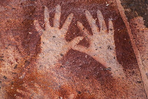
Image from
Wikimedia Commons is by LuigiStudio
Source of information: Wikipedia
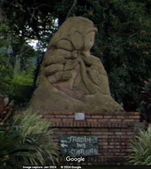
Hand Sculptures at Jardim das Esculturas, São João dos Mellos, RS, Brazil.
The Sculpture Garden in the rural area of Júlio de Castilhos, RS, Brazil, spanning 70,000 square metres, is one of the largest sculpture parks in Latin America. Established in 2005 by owner and sculptor Rogério Bertoldo, it showcases over 700 outdoor works, including hand sculptures. Remarkably, the entire collection was created by Bertoldo himself.
Image from Google Maps is by
Roberto
Lima de Halluli

Image from Google Maps is by
Lisandro
Curto

Image from Google Maps is by
Rosane
Silva vieira

Image from Google Maps is by
J. Fauri

Image from Google Maps is by
Rosane Krug


Image from Google Maps is by J. Fauri
Image from Google Maps is by
Viro
Francisco Frantz

Image from Google Maps is by
Ivan
Bachmann

Image from Google Maps
is by J.
Fauri

A 6-finger hand
Image Source: Google Street View
(Photosphere) by
Gabriel
oestreich. This Photosphere shows some more hands.

Source of information: https://www.viagensecaminhos.com/jardim-das-esculturas/
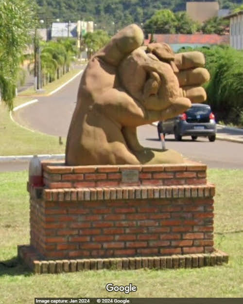
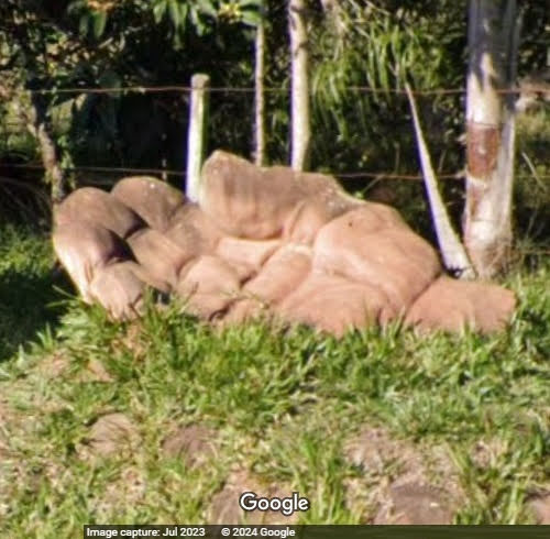
Giant Hands along the Roads to Sculpture Garden, RS, Brazil.
The Sculpture Garden in the rural area of Júlio de Castilhos, RS, Brazil, is one of the largest sculpture parks in Latin America. The roads leading to the Sculpture Garden are dotted with several giant hands as waymarkers. These hands, like the other sculptures in the Sculpture Garden, are the artwork of sculptor Rogério Bertoldo, who is also the owner of the Sculpture Garden.
10.6 km marker on the Nova Palma road to the Sculpture Garden.
Image Source: Google Street
View
9.2 km marker on the road from Nova Palma to the Sculpture Garden.
Image Source: Google Street
View

8.3 km marker on the road from Nova Palma to the Sculpture Garden.
Image Source: Google Street
View

7.3 km marker on the road from Nova Palma to the Sculpture Garden.
Image Source: Google Street
View

6.7 km marker on the road from Nova Palma to the Sculpture Garden.
Image Source: Google Street
View

5.6 km marker on the road from Nova Palma to the Sculpture Garden.
Image Source: Google Street
View

5 km marker on the road from Nova Palma to the Sculpture Garden.
Image Source: Google Street
View
3.6 km marker on the road from Nova Palma to the Sculpture Garden.
Image Source: Google Street
View

3.2 km marker on the road from Nova Palma to the Sculpture Garden.
Image Source: Google Street
View

1.2 km marker on the road from Nova Palma to the Sculpture Garden.
Image Source: Google Street
View
6.6 km marker on the road from Ivora to the Sculpture Garden.
Image Source: Google Street
View

2.2 km marker on the road from Ivora to the Sculpture Garden. This is one of the two hands at this location.
Image Source: Google Street
View

2.2 km marker on the road from Ivora to the Sculpture Garden. This is the second hand at this location.
Image Source: Google Street
View

Giant Hands Supporting the Roof and Pillars of Hotel Lobby, Bogotá, Colombia.
Decorative artwork at AC Hotel Bogotá Zona T, Bogotá, Cundinamarca, Colombia.
The original, larger image is available at
this link.

Image from Google Maps
is by Jaime
“Jimmy” Moreno

Few more hand supports can be seen in Google Street View.
Giant's Hand Viewpoint, Gigante, Huila, Colombia.
Mirador La Mano del Gigante (English:Giant's Hand Viewpoint), a viewpoint designed as a giant hand near the town of Gigante, Huila, Colombia. A real coincidence is that the town itself is named Gigante, meaning giant.
In 2020, the name of the area where the hand is located was changed to Montaña La Mano del Gigante, meaning Giant's Hand Mountain.
Image from Google Maps
is by
Andres Felipe Aponte Galvis

Source of information: huilamagnifica.com
Giant Hand Holding A Huge Sphere, Tocancipá, Colombia.
Monumento la Mano de Dios (Hand of God Monument) is a huge hand monument in the Jaime Duque Theme Park in Tocancipá, Cundinamarca Columbia.
The sculpture stands 38 meters tall, and the copper sphere has a diameter of 25 meters. The total weight, including the foundation, is 1250 tons.
Image from Google Maps
is by
Jonnathan Vargas

Source of information: es.wikipedia.org
Hand Pointing to Sky, Quesada, Alajuela, Costa Rica.
La Mano de Dios (Hand of God) is a 12-metre-high monument to the six victims of a private aircraft, a Piper PA-23 Aztec, that crashed here on May 29, 1971.
Image from Google Maps
is by
Javier Calderon

Google Maps. It is not visible in Google Earth imagery or in Google Street View, but is placemarked in Google Maps.
Source of information: sancarlosdigital.com
Giant Hands at Nosara Beach Hotel, Nosara, Costa Rica.
An amusing piece of decorative architecture at the hotel is a giant hand plucking the tall spire of the hotel.
Image from Google Maps
is by
Dagmar Dolatschko

The zoomed view of the hand can be seen the Facebook page of the Nosara Beach Hotel.
There is another large hand at Nosara Beach Hotel, a hand hanging from the ceiling, probably the ceiling of one of the rotundas at the hotel.
Image copied from
needpix.com is by Quadinsan.

Google Street View is not available. However, it can be seen in this Google Maps photo.
Credits:
I am thankful to all the artists/photographers/organisations who gave me permission to use images from their websites. Individual acknowledgments are given under the relevant images.
I also thank all the Travel Guides of Google Maps whose photos, uploaded to Google Maps, have been used in this collection. Wherever possible, I normally send individual acknowledgments to all those whose images I use in my posts. Unfortunately, there is no way I can contact the Travel Guides of Google Maps. It was possible until Panoramio and Picassaweb were available, however, with their demise, I am unable to send acknowledgements individually.
I am also thankful to my fellow members of the Google Earth Community Forum, namely dagger66, hhgygy, jesusmx, johnluke, krenek, syzygy, walter_v_r, and willi1. They not only informed me about the many hands included here but also helped me find the locations of quite a few of these hands.
Read more...

